Backpacking The Trans-Catalina Trail
- Updated: March 30, 2018
- Post By: Matthew Hengst

March 30th to April 3rd, 2018
Mount Orizaba (2,125')
Mount Torquemada (1,136')
Santa Catalina is one of several islands located a relatively short distance off the coast of Southern California.
It's permanently inhabited by around 4,000 people most of whom are centered around the main settlement / tourist attraction known as Avalon. Most of the rest of the island is controlled by the Catalina Island Conservancy and has a more rustic feel to it despite the existence of dirt roads and cell service almost everywhere. They do control vehicle access but you can pay to get almost anything including yourself delivered to one of only 5 campgrounds.
The island is also famous for the buffalo herds that were originally transported to the island for a movie only to be abandoned and have lived there ever since. And there's also a unique species of fox that is only found on the island.
There is a trail that runs from one side to the other called the Trans-Catalina Trail that's been on my radar for years. Since I'd only ever been to Avalon it seemed like an ideal way to see more of the island. I never got around to it before now mostly due to the cost and extra hassles involved vs my usual Sierra or desert based weekend adventures. You have to reserve campsites, pay for a boat ride, and I'd heard from others that it was mostly a steep hike on fire roads.
Then this year I let Jen Blackie convince me to finally take a precious four day weekend in between WTC and AMP and head out there. And it turned out to be one of my favorite trips of the past few years despite the odd mix of civilization (cellphone coverage, vehicle access to the entire island) intruding into the wilderness-y experience I'm generally looking for.
I hadn't been feeling great in the two weeks prior to this trip. I got sick the week before WTC Snow Camp, went anyway because of course I did, got even more sicker by the time I came back, and then sadly had to cancel a trip the following weekend after I found myself physically unable to make it down the stairs at me apartment. (I did try several times before reluctantly admitting defeat.
 |
| WTC Snow Camp 2018 or how *not* to recover from a major illness |
So after having been bedridden off and on for two weeks I was a more than a little concerned that maybe I wasn't recovered enough to manage this trip. Unfortunately we didn't have a lot of flexibility to put it off considering my slightly full weekend schedule and the several hundred dollars of reservations we had already made.
Of course we had to decide what version of the Trans-Catalina Trail to do. If you've been looking around online for information you've probably noticed not all of the maps seem to agree and several of the trip reports sound like they didn't do the same thing.
 |
| Trans-Catalina Trail 2017 |
This is the current version as of 2017 and you can see the trail leaves Avalon via Hermit Gulch and ends at Parsons Landing on the far end of the island.

Earlier versions have it starting from Pebbly Beach and adding in a section of trail on the eastern end of the island and also it extends all the way out to Starlight Beach on the western end.
Jen hadn't originally had strong feelings about the route more just wanting to hike on the island but once I was involved I insisted we do the entirety of the trail. After all if I was going to spend 4 days out here I wanted to see everything!
We also had to make decisions on where to camp. There is no camping on the island outside of the established campground at Hermit Gulch, Black Jack, Little Harbor, Two Harbor, and Parsons Landing. Most people do some of the campgrounds but not all.
Black Jack and Parsons were an easy call but while many people stay at the campground at Two Harbors in order to divide up the mileage a bit better we elected for Little Harbor. This shortened the second day while giving us a much longer third day but we decided it was worth it due to Little Harbor getting rave reviews online vs Two Harbors which has more of a reputation for being expensive and sometimes a bit loud.
An oddity of trying to make campground reservations is that the online interface only allows you to reserve a minimum of two nights. However, you can call Two Harbors Visitor Services and they will help you make all single night reservations and help you with any of the details so it's strongly recommended to go that route.
Campsites fill up early so you have to book far ahead. We met a number of folks who were adjusting their plans because they hadn't managed a spot at one site or another.
Cost wise it wasn't super cheap.

That's not counting the backpacking food we brought along. This is quite a bit more than our average cost getting up to the Sierra or out to the desert though you don't have to factor in gas here. Note that we could have easily saved $76 if we'd gotten a ride to / from the ferry vs leaving our vehicle and we maybe splurged a bit much on post trip beer at Two Harbors.

Speaking of backpacking food we did bring fresh food to cook every night and two liters of wine. That meant our packs were quite heavy but hey, it's all conditioning for the next one!
Presumably it would be possible to bring two days of food and resupply in Two Harbors. (We briefly discussed trying to find another bottle of wine there but ended up distracted by some really great breakfast burritos!)
The other slightly odd thing is that you have pit toilets or porta potties everywhere along the route so bathroom kits are unnecessary. Water is available at every campground except for Parsons where they deliver jugs as part of your campsite reservation and you have cell service almost everywhere. When we ran into an issue at one of the campgrounds the solution was literally to pick up the phone and call Visitor Services which just felt weird! But it does mean you can tease your family and friends with pictures along the way!
Day 0
Avalon Dock To Hermit Gulch Campground
1.7 miles, 330' gain


Vacation days are precious things for me and with the aggressive schedule we had set for the next day we wanted to get off to an early start. Also I tend to get want to get moving and start the trip as early as possible so we planned to ride out to the island Friday night after work.
We left work in Orange County at 4 pm and drove up to San Pedro where there is a 7:15 pm ferry that gets you to Two Harbors by 8:30 pm and then continues on to Avalon arriving a bit after 9 pm. Tickets were $73.50 for two of us.

The ticket asks that you arrive 30 minutes to an hour ahead of time and we had anticipated worse traffic than we actually ran into so we were there a good hour earlier than we needed to be. There's a restaurant, a bar, and a decent wait area all of which was practically deserted.

We camped out on the top level of the boat which was nice and quiet until some college kids came up and started drinking and generally being obnoxious. Fortunately they were staying at Two Harbors Campground so we wouldn't be seeing them again.

The boat stopped at Two Harbors and then dropped us off at at Avalon a bit before 9:30 pm.

Unfortunately I'd made the mistake of actually reading the ticket agreement and they explicitly tell you not to pack butane or propane stove fuel in your bags for the boat ride for safety reasons and insist you buy them on the island. However no one checked our bags and everyone else we talked to had just thrown their canisters in their pack so I'd recommend ignoring that.
We tried to find some butane canisters on our way through Avalon so we could make breakfast in the morning but we had no luck with the few stores that were open that late. We decided we'd have to settle for sleeping in a bit and waiting for the camp host at Hermit Gulch to open in the morning.
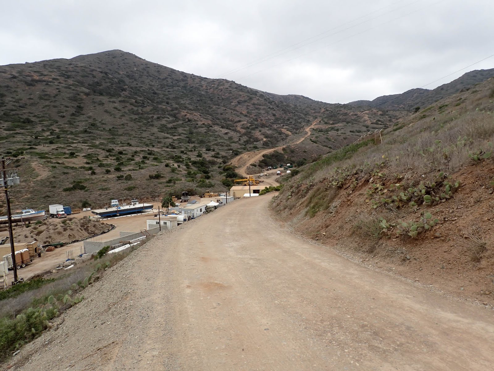
The moonlight hike up the road to Hermits Gulch was short and pleasant. We arrived at the campground to find it lightly occupied and instead of taking our assigned spot we found one along the back far away from everyone and gratefully sacked out on the grass.
Day 1
Avalon To Black Jack Via Renton Mine Road
16.6 miles, 4,000' gain


We woke up the next morning with deer looking at us from about 10 ft away and a pleasant fog rolling through the campground.

Hermit Gulch Campground feels like a park that just happens to allow camping. Lots of grass, good bathrooms, ample water, and there's even tent cabins available if that's your thing.

We bought a fuel canister off another group so we could make breakfast before the camp host was up only to later find that people had left partially filled canisters on top of the fuel disposal box free for the taking. Jen had one of her periodic spurts of cheapskate hippiedom and gave me all sorts of crap when I insisted we still buy a new full fuel canister instead of carrying 3 or 4 partially full cans and risking not being able to make our morning coffee.

This is that newer trailhead that leaves directly from the back of the campground instead of starting back in Avalon.

But we were here for the "whole" Trans-Catalina Trail experience so once the campground host woke up and we were able to get our full butane canister we shouldered our packs and set off back down the road to Avalon.

This was less exciting than the moonlight hike the night before but we were soon back in town.

I'd found information online that the road out to Pebbly Beach Road was temporarily closed (though I have my doubts that was actually the case) and to use Wriggly Road instead.

Both Pebbly Beach Road and Wrigley take you out to Renton Mine Road but the Wrigley variation has the advantage of stretching out the gain a bit instead of making you climb straight up out of Pebbly.

It also gave some rather nice views of Avalon as we climbed.

We walked past a roadside pet cemetery and then soon after an area with lots of stacked rocks. Not sure on the significance of the latter and I'd be interested to hear from you if you can explain the context.

We reached Rendon Mine Road and finally got off the pavement starting the "trail" proper. If by "trail" you mean a dirt jeep road.

By this time I was coming to the conclusion that I was finally recovered and started to relish charging up the hills despite the heavy packs on our backs. Jen's trudged along behind with slightly less enthusiasm.

We didn't see any other hikers until later in the day but we were passed by a tour vehicle filled with people who eyed our packs and sweat stains with something akin to horror.
We passed the junction leading back down to Hermit Gulch Campground around noon and while we didn't regret the extra extra miles we both commented that they didn't add a whole lot to the experience. The eastern end of the island is fairly arid and you're just walking along a hard pack jeep road for miles with a view mostly consisting of the interior of the island.

After the junction we started seeing more people. It's also really developed with full on pit toilets every few miles. No catholes on this trip!

The hike was on dirt roads until we got near Haypress Reservoir and then you're paralleling the road at a short distance.

It was a warm day so we took advantage of the water fountain at Haypress to fill up and also saw our first buffalo munching away on some bushes a short distance away.

No foxes though despite a fair amount of signage.

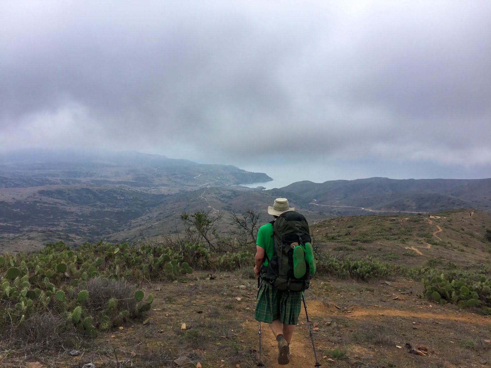
After that the trail started to diverge more from the road and do a fair amount of up and down in small canyons. We could what had to be Black Jack Campground in the distance since the trees stick out from the much more limited scrub everywhere else. The peak to the right of me in the picture above is Black Jack Peak while to the left is Orizaba the island high point. The campground is right below and to the left of Black Jack Peak where you can see a grove of trees.

The last few miles before the campground finally felt a bit remote. It also felt like our rapid progress from before had slowed down a bit but hey, we were over 15 miles in at this point.

We arrived at Black Jack Campground around 5:30 pm. The picture above is of the upper section which is where the bathrooms and lockers are. There were two larger sites below which were populated by two larger groups.
The sites all had fire pits and large water barrel to douse campfires. Wood apparently gets delivered if you pay for it when you get your campsite reservation but we'd only elected to do that at Little Harbor and Parsons. There was also drinkable water available in the center of the campground and an outdoor shower that I only found as we were leaving.

Our site was in the middle of several others which was a bit of a bummer but as it turned out only one of the sites around us was even occupied.

There's no power here now but existed at some point based on the old wiring next to our park bench. There was cell reception.

We saw a few buffalo off to the side as we came into camp and were told the main herd was actually a short distance on the far side. The people in the site next to us actually had to bushwack around them to get into camp. Neither of us were feeling particular motivated enough to walk over and see them consider sitting and drinking well earned wine was an option.

Lucky for us the herd decided to wander through the campground right before 7 pm so we had the best of both worlds!
I enjoyed the feel of the campground since it felt remote tucked away in the trees. In addition to the buffalo there were a ton of birds fluttering around which was quite nice. At least until I got dark and we were trying to sleep.
There was one bird in particular (which we now think was actually a squirrel) which spent the entire night chirping incessantly in a way that kept us both partially awake until it finally stopped right around dawn. Which was about when the woodpecker found the metal post of the BBQ setup behind our camp and started having fun slamming its beak against the hollow metal.
So needless to say I liked the campground but we didn't have the best night's sleep.
Day 2
Black Jack To Orizaba To Little Harbor
11 miles, 2,000' gain


Despite the sleep challenges it was another beautiful morning with the fog rolling through camp. We had the easiest day of the trip planned just having to get over to Little Harbor Campground and there was even a meal stop option along the way at the airport.
(As I mentioned above this was a shorter day because we'd decided to stay at Little Harbor instead of Two Harbor since it sounded like a better camping experience)
Black Jack is located practically between two peaks one of which (Orizaba) is the island highpoint. We'd eyed a few other named bumps along the way the previous day but the fire roads and antennas made us reconsider. Orizaba seemed like it would be worthwhile though.

We followed a road that split off just past camp and started climbing.

There were two fences along the way we had to hop. Neither had a no trespassing sign and we'd seen countless reports online of people climbing this route so we decided to risk it figuring anyone seeing us from a distance likely had better things to do than harass a few peakbaggers.

The top was...eh. Granted we had clouds in every direction so we didn't have a great view but the top is a large flat area with a radar installation. We took a few pictures and then headed back down to camp.

Since we had cell reception I checked online and saw that Black Jack Peak was more of the same so we elected to skip that.

Back at camp everyone else had cleared out though there was a group of rather pleasant German's who were there day hiking and seemed rather amused by my kilt. We'd end up running into several times over the next few days.

We packed up our camp and got moving a little after 10 am. From Black Jack the trail dropped down and then climbed back up the far side. I was happy to see we were on actual trail vs road at this point!

At the top of the hill is the rather dramatically named Airport In The Sky. In addition to being an airport it's a common shuttle destination *and* a restaurant. Which more importantly has beer! (And coffee)

We'd been sweating profusely for the better part of two days at this point so we shared a hamburger and a beer before exploring the interpretive displays outside.

We saw a number of folks who we'd run into earlier on the trail. Again the kilt apparently made me stand out just a bit.
Past the airport we had a few short hills to climb but it was mostly downhill to get to Little Harbor. Along the way the clouds built up and it misted just enough to get us to put on our rain jackets but never really started raining.
Even with our relaxed pace and ample break at the airport we made it into Little Harbor at 2:30 pm.

My expectations for this place were high based on what I'd seen online. The reality was this was probably my least favorite of the campgrounds we stayed at during our trip though that's partially due to getting site 15'd.
I was hopefully optimistic when we rolled in and we relaxed on the grass for a few minutes while Jen dug out our campsite reservation. She's just asked for any site when she made the reservation and it turns out there are a few different areas.
In the lower part of the campground you get green grass and a few of the sights even butt up to the beach. Then there's the plateau above which has site 15, 15a, 16, and one other.

Located up a hillside from the main camp area it's pretty much dirt / mud with scant vegetation. Site 15 had a single tree that seemed to be dying. It also wasn't exactly flat. And instead of an ocean view you had more of a partial view of the people camped down in the nice grass sites below and a pretty good view of a bloody RV camping loop at the back of the campground.

So not my most favorite campground experience.

We ended up switching to the unoccupied site 16 with the blessing of the camp host and that was at least flat. The camp host also sold us a second bundle of wood for $10 which we decided would help a bit with the dreariness of the day.

We hiked down to bay to look around. Based on pictures I've seen online it's quite a bit more striking when the sun is out but even with the overcast sky it was quite pretty.


See that little lump to the left of the rock out in the beach? That was a seal that was flopping it's way up the beach at a painfully slow pace. It almost seemed like there was something wrong with it and I made the mistake of making that comment to Jen.
At which point she sprang into action and called the Catalina Marine Rescue Hotline using her cell (again we had reception) In other news there is a Catalina Marine Rescue Hotline which I had no idea about it. In a conversation where I'm about 90% sure they were convinced they were talking to an overly innocent teenage girl the guy on the other end of the phone assured her that it was most likely an adolescent elephant seal, that it was probably fine, and that that was pretty much how they go about life.

Meanwhile he just kind of flopped around a bit.

Back in camp we settled in for another fancy dinner and the last of the red wine while we listened to the mother daughter pair in the camp behind us singing along to some sort of guitar. The two bundles of wood lasted a surprisingly long time and we could just barely hear the sound of surf in the distance in between people noises from the campground below and the RV generators off behind us.
Day 3
Little Harbor To Parsons Landing Via High Route
14 miles, 4,000' gain


We had decided we wanted to get up early for the next two days considering we had a lot of miles to cover. We were awake before dawn and quietly went about getting ready trying not to disturb the folks in the camp across the way. By 6:30 am we were moving.

Most people seemed to be sleeping in but we did pass one couple as we climbed the hill just past camp.

And man did that sucker go up! We commented a few times how this trail must just be murder to the folks who don't hike a lot as we climbed from sea level up to about 1,200'.

Once we gained the high point we did start to get some more exciting views of the ocean than what we'd seen so far.

And then of we dropped 1,200' back down to sea level at Two Harbors. And that was the smaller of the two hills for the day.

This was my first time in Two Harbors and I have to say I liked the vibe significantly better than Avalon.
We checked in at the visitors center for our stay at Parsons (despite what the website will tell you we were told not to check in for Black Jack or Little Harbor) and set about on the important task of locating food.

I still say that that was the best breakfast burrito I've ever had. Blondie is just wrong so we won't ask her opinion. After a copious amount of food and coffee we were feeling content and ready to head on to Parsons.
There are technically two ways to get to Parsons from Two Harbors. You can take the boring road that runs along the coast and has pretty much zero gain or you can take the awesome steep route out of Cat Harbor and see the island interior. Guess which we did? :)
The road is a climb but it went quickly and starts to feel remote as soon as you start up the hill.

We were pretty turned off to Catalina peakbagging after the last few days but we decided to make a side trip out to Torquemada just because it was a cool name and not too far of a detour.

That turned out to be the best decision we'd made at since getting those breakfast burritos as the trail followed a narrow ridge hundreds of feet above the water.

It's really a shame the trail doesn't have more bits like this as it was a highlight of the trip.

This is the view from the top looking back down at Cat Harbor.
Retracing our steps back to the road we continued on towards Silver Peak.

We had been debating what exactly we wanted to do here. One option was to skip Silver, drop down to Parsons, and reclimb the 1,700' we'd lose the next morning. Another was to hit Silver and either backtrack or continue around to the west and rejoin the trail leading from Parsons to Starlight. Going to Starlight today would be doable but we'd have to really push it to make it to camp before dark.
What finally decided it was a combination of seeing the peak clouded in and me wanting something significant to do on our last day.

This was a great, super awesome, and amazing plan that was totally worth it no matter what Jen might tell you. However be warned the road we took down (and up) is called Fence Line and is a bit on the steep side. On the plus side you don't waste a bunch of time on switchbacks.

This whole side of the island was much more to my liking. There's more vegetation and less civilization going on.

Roughly 1,700' downhill and one minor shortcut later we arrived at Parsons.

I'd had my expectations lowered by Little Harbor but Parsons blew me away. It's small and all the sites are far enough from each other where the sound of the surf pretty much takes away any people sounds. There's a row of porta potties up above (which was the only part of the campground to get cell reception) and we found a water jug and wood bundle marked left out on the deck with our names.

Our site was out in the middle maybe 20 ft from the water.

We even had a boulder right in front of our site that someone proceeded to free climb while Jen and I looked on impressed and discussed cspine injuries and quasi wilderness evacuations.

We struggled a bit getting our wood bundle to light just due to the moisture but once it was going the fire felt quite nice in the face of the damp breeze blowing in off the beach. The rock walls everywhere help keep you out of the worst of it.

We were both beat up from a solid day of hiking but this was one of those rare campsites where I was reluctant to go to sleep just because I was enjoying the ambiance so much. Eventually I did drift off listening to surf sounds.
Day 4
Parsons Landing To Silver Peak To Starlight Beach & Back To Two Harbors
17.6 miles, 3,600' gain


We had another big day and a boat to catch at 4:30 pm so we were up well before dawn and headed back up Fence Line Road.

It was a muggy morning but the sunrise views along the way more than made up for the early start.

As I mentioned the road is a bit on the steep side...

By the time we reached the junction leading out the Silver the clouds had cleared and we had great views in every direction.

The road ran right under the peak so it was only a diversion of maybe a hundred feet up an easy hillside to reach the summit.

We found a register packed full signatures and the usual trinkets.

The island really starts to narrow so you get a much stronger sense of being on an island out here. We also saw a few foxes and bald eagles along the way!

After Silver we dropped steeply down the road until it ended rather abruptly at a sign declaring you've reached Starlight Beach.


You have to downclimb a bit to get to the beach but it's well worth it. After a few hard days of sweating like crazy it felt great to take a swim.

Sadly we were feeling the time pressure so we had to get moving sooner than I would have liked. Next time I'm going to budget more time between here and Parsons.

The hike back to Parsons is relatively moderate and at one point you have the choice of dropping down and then regaining the altitude or doing a small amount of extra climbing for a high route. We went high and were rewarded with an honest to god single track trail with great views for a while. We both commented that it was a shame there wasn't more segments like this on the TCT.

We were back to Parsons a little before 11, packed up, and headed out via the 7 mile flat -ish dirt road back to Two Harbor.

The road wasn't my favorite part of the trip.

The views of some of the bays were spectacular particularly now that the sun was out and the blues really popped. The problem was you can't stop anywhere and get down to the water.

It seemed like every single bay was marked private property and hikers were directed to stay on the road.

But hey, we were on a mission anyway.

My feet were killing me thanks to the hard packed dirt road (and maybe the fact we'd been hiking 60 -ish miles) so I was quite happy when we strolled on into Two Harbors a little before 2 pm. And even better since our boat didn't leave until 4:30 pm we had time for the important things.

Similar to the breakfast burrito we'd had here a few days ago the beer and burger combo were both amazing. Best (and only) restaurant in town!

Even better we found out the general store serves ice cream complete with whipped cream and sprinkles! And we saw a number of people we'd met on the trail including the germans who had spent two nights at Little Harbor and then gotten here early enough to relax and swim.
We had plenty of time to eat, drink, and just enough left over to grab some quick $2 showers at the bathrooms across from the restaurant. Interesting enough there was a sign in the bathroom warning about water shortages and encouraging people to use disposable eating utensils instead of anything that would have to be washed. (The Catalina water supply situation makes for interesting reading online if you're interested)

Feeling quite refreshed we boarded the boat and relaxed on the deck for the ride back to Avalon and then on to San Pedro. (Though for the record the overpriced beer on the boat totally wasn't worth it and we should have just had another one or two back at Two Harbors...)

And with that we were back to civilization some 60 miles and 14,000' later. We landed at about 7 pm so it was early enough we had plenty of time to grab dinner and clean up once we got home.
Recommendations
We did the entire TCT but if you want to see the best of what Catalina has to offer I'd honestly recommend just doing the western end of the island as a 3 day.Easier 3 Day
Two Harbor To Parsons Landing via road - 7.4 miles, 1k gain
Starlight Beach via Low Route - 9 miles, 2k gain
Parsons Landing To Two Harbors via Road - 7.4 miles, 1k gain
Total: 23.8 miles, 4,000' gain
Harder 3 day
Two Harbor To Parsons Scenic Route With Torquemada - 8.4 miles, 2,500'
Starlight Beach via Silver Peak Returning via Low Road - 10.3 miles, 3,300'
Parsons Landing To Two Harbors via Road - 7.4 miles, 1k gain
Total: 26.1 miles, 6,800'
For either reserve two nights in Parsons Landing and optionally one in Two Harbor if you want to head over after work. You can take the ferry over to Two Harbors after work and walk a short distance to the Two Harbors Campground east of town to spend the night or save the campground fee and take the first ferry over in the morning.
The first day hike in to Parsons Landing either by the more scenic southern route which is about 8.5 miles and 2,500' gain or the easier yet less remote shoreline route which is 7.3 miles and 1,000 gain. I'd highly recommend taking the scenic route out and then coming back via the road so you get to see more of the island interior and then you can do the brief excursion to Mt. Torquemada which makes for excellent pictures.
Once in Parson relax and enjoy the rest of the day. Two bundles of firewood makes for a nice big fire and this is one of the more memorable campgrounds I've been to.
The next day wake up, hike to Starlight either by the lower route (9 miles, 2k gain) or the higher route which lets you grab Silver Peak which is both the high point of this part of the island and a damn nice view and then return via the lower route (10.3 miles, 3,300' gain). Relax for another night at Parsons.
The next day it's a 7.3 miles 1,000' gain hike out along the road to get back to Two Harbors where the resort has damn good beer and hamburgers and you can even grab a shower before heading back to the mainland.
So that was out little 4 day adventure. I'd do again in a heartbeat though I'd be tempted to do the three day Parsons / Starlight option vs the whole thing knowing what's out there. We also have vague plans for paddling around the island in kayaks whenever the timing works.
Have you done the TCT? What did you think? Do you agree with my opinion on the campgrounds or did you love Little Harbor Site 15?
1 comments
Hey! I'm planning on hiking the TCT this November. I noticed a couple of the days you left your campsite set-up while you took little side trips, something I'm thinking I'll do. I'd like to think that people would have no interest in taking anything - were you at all concerned? Also, did you two have any issues with animal getting into your food?
ReplyDeleteHope to hear back from you :)
Megan