Diving the Vandenberg Wreck In Key West Florida

December 31st, 2018
[Pics] [Map]

Today was to be the crown jewel of dives we had planned for our Florida New Years dive vacation and the one I was the most nervous for.

The Vandenberg is an old military troop transport that was intentionally sunk ship off the coast of Key West as an artificial reef and recreational dive attraction. It's the second largest artificial reef in the world and while it starts at only 45 ft below the surface the bottom is on the sand at 140 ft and most of the interesting attractions require you go down to at least 100 ft.

I was currently straddling Open Water (which allows you to dive to a recommended 60 ft) and Advanced Open Water (which ups that to 130 ft) certifications due to weather holding up the last of the certification dives but after a good amount of research and a warm up dive the day before on the 70 ft deep Cayman Salvager wreck we were all set to at least give it a cautious try.

We had hired a local dive guide through Lost Reef Adventures and after meeting him the day before we ended up requesting Randy Pekarik who I can't recommend strongly enough. Even if you're experienced and comfortable at that depth Randy has over 2000 dives on the Vandenberg and can show you swim throughs and features you probably wouldn't have time to find on your own. Also he brings viking hats for post dive victory shots. Just sayin...

Diving Key West Florida - The Cayman Salvager Wreck (With Horrible Visibility) and 9 Ft Stake

December 30th, 2018
[Pics] [Map]

After yesterday's 6 dives across 3 boat excursions we were a bit run down and majorly low on sleep. Still, we only had so many days in Florida for our News Years 2019 Dive-cation of Amazing Awesomeness so far from taking it easy and doing something unreasonable like sleeping in we were once again up before dawn and headed south along the Keys.

This time we were diving off Key West with Lost Reef Adventures.

We picked our diving days by just looking around online and picking dive shops and excursions that reviewed well and figuring we could change things on the fly if needed. One of the things that jumped out majorly was the the Vandenberg which is a well-known wreck of the coast of Key West.

The only problem was that the Vandenberg was down at 100 ft and the Open Water certification only OK's you for 60 ft these days. After reading online the dive shop said OW divers were fine at long as they had 10 to 15 post cert dives and went down with a guide so we started to hope it might be doable. Just to be safe we decided to book a warmup deep dive to the Cayman Salvager (which is at 70 ft) the day before. And that was today!

Diving Looe Key In The Florida Keys - A 6 Dive Day!

December 29th, 2018
[Pics] [Map]

So far our Florida News Years 2019 Dive-cation of Amazing Awesomeness had consisted of freshwater diving with the occasional manatee belly rub but finally it was time to kick off the ocean diving portion of the trip!

The previous day had been rough with two hour long dives and almost 500 miles of driving to get us from the Crystal River area down to the Florida Keys. We arrived late, fell asleep on a small patch of dirt in the Big Pine Key Fishing Lodge RV Park, and left before dawn.

When we planned the trip today had originally been a rest day of sorts with a single two dive excursion in the morning and tentative plans to explore the Keys a bit possibly snorkeling, paddling, or just catching up on sleep.

But as some of you know I can occasionally be slightly allergic to anything that feels too much like planned downtime. And so while struggling through some enforced relaxation at my parents over
Christmas I prodded Jen into amping up our plans just a bit. An amused Looe Key dive shop said that they had morning, afternoon and night dive boat options and happily confirmed us for all three giving us 6 dives for the day and not a lot of downtime. Now we were talking!

Ginnie Springs Ballroom Florida Freshwater Cavern Dive & A Disappointing Failure To Find Herpes Monkeys

December 28th, 2018
[Pics] [Map]

We had decided on Devil's Den first and then looked around for what other diving options we could fit in before driving south towards the Keys. We ended up settling on Ginnie Springs because it was another cavern advertised as safe for Open Water divers but seemed like it would be a bit of a progression from Devil's Den.

Jen was nervous at first but we decided we'd go in and take a look and turn back if it wasn't something we were comfortable with. For what it's worth we both found it to be straightforward but well worth the side trip if for no other reason than the visibility in the spring was something like 200 ft!

Devil's Den Florida Freshwater Cavern Dive

December 28th, 2018
[Pics] [Map]

Devil's Den is easy to find online because the pictures taken there are spectacular. It's hard to see the blue water cavern with sunlight streaming down from above and not want to go visit.

This was our second day of diving activity on our Florida News Years 2019 Dive-cation of Amazing Awesomeness after the previous days drift dive in Rainbow River. This was a whole different experience since there are less fish and no plants inside the cavern.

Rainbow River Freshwater Drift Dive, Florida

December 27th, 2018
[Pics] [Map]

Next up on the Florida News Years 2019 Dive-cation of Amazing Awesomeness was a freshwater drift dive in Rainbow River!

Freshwater diving was briefly mentioned during my Open Water dive certification but 99% of the focus there was on diving saltwater. So when we were looking for diving options around Crystal River and came across this I wasn't quite sure what to expect. The dive shops bill it as something anyone can do since you can have people tag along with snorkels, kayaks, or just ride along on the boat.

After looking up some trusty YouTube videos I started getting exciting and sure enough it was amazing!

Snorkeling with the Manatees in Crystal River Florida

December 27th, 2018
[Pics] [Map]

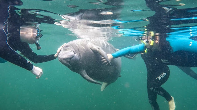
This was the first activity of our eight-ish day Florida News Years 2019 Dive-cation of Amazing Awesomeness. Up until this trip I only had a vague awareness of manatees but it turns out Jen has been fascinated by them since learning about them from some school assembly as a child. When we first came across the option of swimming with manatees while trying to pull off this last minute Florida trip she was ecstatic and insisted that we try and make it work.

Florida News Years 2019 Dive-cation of Amazing Awesomeness! - Planning & Particulars

Florida News Years 2019 Dive-cation of Amazing Awesomeness!
December 26th 2018 to January 2nd 2019
[Map]

This trip was yet another last minute -ish see what we can manage with what we got sort of trip. I knew I was spending Christmas in Colorado Springs with my parents and I knew I wanted to do something significant for New Years. Initially Jen and I toyed with running back out to Arizona and building a trip around a that technical route we'd failed on last year but the more we talked about it (and the more Kristen talked about her trip to Thailand which involved diving and had been the trigger for me getting my cert) we kept coming back to diving.

We briefly considered just running around SoCal trying to get in as many dives as we could but that didn't seem suitably epic enough for a New Years trip. So we started looking for diving destinations with limited travel time that we could make work within a reasonable (for diving) budget.

We settled on Florida which I'd never been to and Jen had only ever been there as a child. I could use airline points for the flights and we could camp instead of staying in hotels to save money. And then of course we proceeded to jam in as many activity as we possibly could in the time had which kind of left the whole affordable aspect in the dust.

But hey, it was an epic new year trip!

Diving La Jolla Shores - First Time Diving On Our Own

December 15th, 2018
[Pics] [Map]

As I've recounted elsewhere the last few weeks have been a somewhat hurried progression towards getting our Open Water diving certs and starting Advanced Open Water classes in order to get ready for some diving-centric plans around New Years.

Friday Kristen and I had both taken the morning off work in order to do our 4th and final Open Water cert dive at Crescent Bay in Laguna. We did that instead of waiting for Saturday since that way we could rent two tanks and get out on our own. Also we were going to be down towards San Diego anyway since we were scheduled to be on a boat with Sea Stallion on Sunday for a few specialty dives so it all worked out.

Observation Point Zion Peakbagging

November 25th, 2018
Observation Point (6,507')
8.4 miles, 2,100'
[Pics] [Caltopo] 

Zion is a funny place since it's becoming increasingly popular yet there really isn't as much to it as some of the other National Parks. The main canyon is stunning but so choked with people they have to shut down the park entrances on a regular basis to avoid it turning into one long angry parking lot.

And when it comes to hikes the thing that most people know about Zion is Angels Landing aka that scary thing your Aunt did once where she thought she was going to die.

Now don't get me wrong Angels Landing is a fun little hike and there are enough narrow sections to make the pit of your average persons stomach drop a bit but it's also a well-maintained trail with chains to hold on to whenever you get anywhere near an edge. The first time I did it my girlfriend at the time had really worked herself up about the exposure only to comment she felt somewhat less badass considering we were passing 6-year-olds along the chain.

So, Angels Landing is fun but not the end all be all of Zion. For my money if you want to do something and see the best view of the park from the front country then Observation Point is the thing to do. It's all on trail and doesn't have the exposure issues but the view from the top looks straight down the main canyon and you even get to look down on all those people on Angels Landing.

Roof Peak & Hepworth via Gifford Canyon Zion

November 24th, 2018
Roof Peak (6,553')
Hepworth (6,548')
7 miles, 2,600'
[Pics] [Caltopo] [Map]

I hike a fair amount. Some would even venture to categorize it as "a lot"  So you would think that after 10 ish years of this I'd be fairly well adapted and basic hikes would, in general, go smoothly. And you would, of course, be completely incorrect.

It seems like there's always some new sort of issue cropping up so it shouldn't have been a huge surprise when I woke up and made the long fridged stroll to the campsite bathroom only to realize I was having a rather major chaffing issue that was going to make any hiking rather unpleasant.

But hey, it's a Matt trip, it's freezing, and things go a little wrong. Life as usual!

Nippletop Zion Peakbagging

November 23rd, 2018
Nippletop (6,715') 
3 miles, 1700'
[Pics] [Caltopo] [Map]

We didn't finish our climb of Jenny Peak and Jenny's Nipples until almost 2:30 pm which only left us with a few hours before dark. And going along with our periodic Thanksgiving trip nipple theme we decided to knock out Nippletop!

Nippletop is another fairly obscure peak on the eastern end of Zion far away from the usual tourist-friendly activities in the main canyon. It's a good way to spend a few hours while getting in some unique views and welcome solitude assuming you're ok with a bit of loose 3rd class scrambling.

This was a part of this year's Thanksgiving trip aka the 2018 Turktacular!  This year I was out in Zion Utah climbing a series of smaller peaks. For the other days see the tag Turktacular 2018 and for what I've gotten up to other years see the tag Turktacular.

Jenny Peak & Jenny's Nipples Zion Peakbagging

November 23rd, 2018
Jenny Peak (6,310')
Jenny's Nipples (6,240')
3.9 miles, 1,500'
[Pics] [CalTopo] [Map]

Jenny Peak is an obscure bump in an area of Zion National Park that doesn't see near the amount of traffic as the main canyon. The peak itself is lower than a lot of its neighbors but it makes for that with the enjoyable class 3 -ish scramble and a summit view that engulfs you in a spectacularly beautiful and underappreciated area of the park.

It's also apparently located in a closure based on what I found out after we did the peak. We didn't see a single sign anywhere along the route but YMMV.

This was a part of this year's Thanksgiving trip aka the 2018 Turktacular!  This year I was out in Zion Utah climbing a series of smaller peaks. For the other days see the tag Turktacular 2018 and for what I've gotten up to other years see the tag Turktacular.

Zion Turktacular 2018: Plan C It Is!

November 22nd, 2018
[Pics]

This was the initial day of this year's Thanksgiving trip aka the 2018 Turktacular!  This year I was out in Zion Utah climbing a series of smaller peaks. For the other days see the tag Turktacular 2018 and for what I've gotten up to other years see the tag Turktacular.

This trip was rather last minute even by my standards. Due to various life events the original plan of flying down to La Paz and doing a paddle centric trip similar to the San Juan Islands trip fell through leaving us scrambling for something to do within driving distance.

Further complicating the situation a storm was coming in and seemed to be hitting everywhere. Friends up in Bishop reported snow down to 6,000 ft and every forecast we checked across California, Nevada, Arizona, and Utah all predicted precipitation.

Granted we've had forecasts like that before and still managed to have some fun. It did mean a lot of the initial ideas I had like Snow BM just were not going to be feasible.

We settled on chasing some lesser known peaks on the east side of Zion and decided to drive out Wednesday night...which due to various last minute complications also didn't happen.

Open Water Scuba Certification With SSI & Sea Stallion


As anyone reading this site probably knows I'm a guy that likes to be outdoors. Usually it's backpacking or mountaineering, sometimes just hiking, sometimes rock climbing, occasionally caving, and when I can swing it paddling or cycling.

Scuba diving has been one of those things I've always wanted to do but every time I would consider it I was put off by the cost. Then finally a few months back Kristen decided to take a New Years trip to Thailand which included an opportunity to scuba dive and she pushed me to join her getting certified.

Piute Mountain From Robinson Creek

September 29th to October 1st, 2018
Piute Mountain (10,541')
Day 1: 10.8 miles, 3,100'
Day 2: 16.8 miles, 4,200'
Day 3: 10.2 miles, 800'
[Pics] [CalTopo] [Map]

September has been a rough month for me. After a strong summer a confluence of health issues forced me to drop out of several trips and dial back others.

I was finally starting to feel at least somewhat better though not quickly enough to salvage the four-day buttkicker trip to Zion I had scheduled for this weekend. When it became apparent that it was going to be best to reschedule that trip Jen and I decided to head up to the Sierra and try something moderate without the pressure of having a group relying on me. After looking at options we settled on Piute Mountain located in a remote part of Yosemite and accessed out of Twin Lakes (the one north of Mono Lake not the Mammoth one.)

Sibling Sierra Sojourn To Mount Silliman

September 21st to 23rd, 2018
Mount Silliman (11,188')
Day 1: 5.2 miles, 3,400'
Day 2: 2 miles, 1,400'
Day 3: 5 miles, 100'
[Pics] [CalTopo] [Map]

A little known personal fact is that I was adopted when I was just a few days old. The next 30 some years I didn't have any contact with my birth family despite a few attempts from both sides to find each other.

Then came a Facebook message from a stranger pointing me to a post on a Texas adoption registry. After a little online digging and 9 months of waiting for someone to check their Facebook non-friend messages I went from being a lifelong only child to having two half sisters and a half brother.


I got to meet Clare, JoAnn, and my birthmother Kim for the first time last Christmas when visiting family in Texas. (My half-brother Adam is in the military and was in Hawaii at the time).

A good time was had by all and when we got to talking Clare, whose hobbies include Crossfit and running marathons dressed as Wonder Woman, was interested in trying out one of the Sierra backpacks I'm always talking and posting about. So I threw out a few options and we settled on a three day to Mount Silliman in Sequoia.

Sawmill Pass

August 31st to September 2nd, 2018
[Pics] [CalTopo] [Map]

This is going to be a little different than my usual Sierra writeups because we didn't make a single peak and not for any entertaining reason like weather, animal attacks, or gear failure. Sadly boring old health issues would cause us to bail out without a single peak.

Still, Sawmill is one of the unmaintained passes in the Sierra that really deserves to have a bit more attention paid to it. It's located near Baxter which is similarly not maintained but unlike Baxter it's actually quite pleasant if you don't mind a bit of steady gain.

This was our Plan B after failing to get a walk in permit for Taboose Pass. Interestingly enough they had to check a map before they would issue us a permit which should give you an idea of how lightly used it is.

Newport Harbor Pizza Paddle - September 2018 With Bonus Peddle To The Paddle Action

August 29th, 2018
[Pics] [Map]

Once a month a group of us get together and paddle Newport Harbor after work. We launch from the beach next to the Newport Aquatic Center and paddle over to Pizza Nova in the main harbor in a combination of kayaks and SUPs. There we dock our boats, partake in a feast of pizza and beer, and then paddle back to the cars. We do this all year round and in pretty much all conditions. Light, dark, rain, and the dead of SoCal winter where you're tempted to put a sweater on with your flip-flops.
You can find write-ups of other pizza paddles here. For notifications on when we're doing the next one see our facebook group Pizza Paddle Associates. (Send me a message so I know you're not a spam bot!)

We've still been doing these monthly -ish but the conditions haven't been ideal for pictures or a write-up. That's unfortunate as we only have another month or two of launching in daylight and enjoying sunsets on the water but at least this months outing was a return to form.

Mount Crocker From McGee Creek *AND* Mosquito Flats

August 25th & 26th, 2018
Mount Crocker (12,458')
Hike In From McGee: 5.9 miles, 2,300 ft 
Hike In From Mosquito: 20.3 miles, 5,200'
Summit Day & Out: 11.9 miles, 2,400'

For years I've joked about having nightmares where I wake up thinking that I have a group waiting for me at both an east side and west side Sierra trailhead. For this and similar reasons I tend to be very transactional for trip signups and planning. See me around town and want to come on a trip? Send me an email. Spend a long 3 day weekend on a trip with me and want to come on something else? Send me an email. You get the idea.

I also have an extensive collection of Google Docs for keeping track of all the various trip details since I plan months in advance and need to keep track of permits, signups, and route details. Generally I manage to stay fairly well on top of everything but things are bound to happen from time to time. So it shouldn't have been a complete shock when on the morning of the trip Kristen pulled out the permit reservation email and we realized that we somehow had 12 participants and only 9 slots

Doh!

Sawtooth Peak, Needham Mountain, and Mineral Peak In Mineral King

August 17th to 19th, 2018
Sawtooth Peak (12,343')
Needham Mountain (12,520')
Mineral Peak (11,615')
Day 1: 5.6 mile s, 3,700'
Day 2: 5.7 miles, 3,800'
Day 3: 6.7 miles, 1,600'
[Pics] [CalTopo] [Map]

This was yet another set of peaks I'd eyed for a number of years but never got around to actually climbing meaning they'd been standing out as the only remaining red dots in the area on my Peakbagger SPS map.

Since pretty much everyone we know who has tried to do both Sawtooth and Needham with a group as a two-day backpack has ended up turning back on Needham we decided to make it three and toss in the unlisted Mineral Peak as a bonus climb. We also advertised it as intending to maximize the 3rd class as much as was reasonable and took the opportunity to camp at the less visited Crystal Lake vs the more commonly visited Monarch Lakes.

Trapezoid, Johnson, and Hurd Peaks Alpine Beer Tasting Climb From Treasure Lakes

August 4th to 6th, 2018
Trapezoid Peak (12,920')
Mount Johnson (12,871')
Hurd Peak (12,237')
Day 1: 3 miles, 1,300'
Day 2: 6.7 miles, 3,400'
Day 3: 5.5 miles, 2,300'
[Pics] [CalTopo] [Map]

Last year a trip to Mineral King to climb my namesake peak happened to occur around the birthday of my good friend Victor Gomez. Seeing as how he is a fellow beer aficionado we turned the latter part of our first day into a lakeside alpine beer tasting event.


It turned into such a photogenically good time we just had to plan another! And so this summer we decided to visit Treasure Lakes in August and climb a few easier (-ish) end 3rd class peaks. And we filled up pretty much instantly.

Mount Ian Campbell WTC Experience Trip

July 28th & 29th, 2018
Mount Ian Campbell (10,616')
Day 1: 4.5 miles, 2,200'
Day 2: 7.3 miles, 1,400'
[Pics] [CalTopo] [Map]

Ian Campbell is a relatively minor named peak near Florence Lake in the Western Sierra. It's not on any list and doesn't particularly stand out from a distance but its located above a spectacular lake that's only a few miles in along a seldom used trailhead. Combine this with the fact the campsite is low enough to allow campfires and the lake warm enough to be ideal for swimming a good chunk of the summer and you have all the ingredients for one of my favorite WTC Experience Trips to lead.

This is the second time I've done the trip with the first time being with Jen Blackie in October 2016. The only real downside is that the drive is on the long side but that can be helped that by having people camp along the way and starting later than usual since it's such a short day in.

This trip happened in the middle of a bad fire season with the Ferguson Fire outside Yosemite causing massive smoke problems across the Sierra. In fact Yosemite itself was evacuated during this time. We decided to do the trip anyway after looking at the smoke modeler here and for the most part it wasn't that bad except in the late afternoons but be aware the views are usually even more spectacular. Unfortunately conditions like these are just a fact of life in the Sierra particularly with the last few years of drought conditions and warmer weather.

Ortega Falls Rock Climbing After Work In Orange County

July 24th, 2018
Ortega Falls Climbing Area
[Pics] [Map]

Most people react with disbelief when you say there's a place to go outdoor rock climbing in Orange County. Outside of a few bouldering areas most of places we climb are too far away for an after work climbing session but there is the small area off Ortega Highway known as Ortega Falls which has a few top rope / trad routes for those willing to brave the canyon traffic.

We planned this for a weeknight since I seem to have filled up all the weekends with out of town trips through at least October. Heat was a concern (especially with the record heat we've been seeing lately) but the alcove where the climbs are located does get shade relatively early and if you're lucky you get a bit of a breeze up top.

Mount Mallory And Lone Pine Peak From Meysan Lakes

July 20th to 22nd, 2018
Mount Mallory (13,845')
Lone Pine Peak (12,944')
Day 1: 5.1 miles, 3,500'
Day 2: 6.3 miles, 3,700'
Day 3: 8.4 miles, 2,500'
[Pics] [CalTopo] [Map]

This was a three-day trip primarily aimed at students who had taken the Sierra Club Wilderness Travel Course though it was open to anyone who follows Sierra Club outings.


This trip came about because Olancha Group Leader Garry McCoppin had been here in the 1980s with a precursor to Wilderness Travel Course when he broke his leg during a glissade gone wrong. He's now in his 70s (and kicking more ass than you'd think possible at that age) and wanted to get up there again to see the area.

I'm always up for an adventure with Garry and we planned a moderate sounding three-day adventure. The first day would be an easy-ish hike into camp where we'd spend the afternoon relaxing and maybe get in a lake swim or two. Then on the second day we would follow the trail up to Mesan Lake and climbed a chute to access Mount Mallory and Irvine. (We didn't make the latter due to weather but I'm not overly heartbroken as it really looks like it's better done from Arc Pass.)

And then we threw in Lone Pine Peak on the last day because it's a) a fun climb and b) so damn impressive from 395 that many people assume it must be Mount Whitney.

Temple Crag From South Fork Big Pine Creek

July 14th & 15th, 2018
Temple Crag (12,976')
7.2 miles, 4,300'
9.3 miles, 3,100'
[Pics] [Caltopo] [Map]

Temple Crag is one of those peaks that is very well known and yet relatively seldom climbed.  It straddles the North and South Fork of Big Pine Creek areas and is probably right up there with Whitney and Lone Pine Peak in how commonly people post pictures of it online and for good reason.


This is the view of Temple Crag from 3rd Lake in North Fork from a trip a few years back.  It pops up early on as you're climbing up the drainage and just dominates the sky.

It's yet another peak I'd tried to plan periodically but never made it up.  The closest I'd ever come was maybe 1/2 of the way up Contact Pass after a failed attempt at the North Palisade U Notch turned into Sil and Gayley with time to spare.  That time my battered knees and the horrible slog up the pass caused me to turn back and eventually make plans for this weekend to get it via South Fork of Big Pine Creek along with Randy de los Santos and Gracia Plascencia.

Mount Emerson SE Face Route Piute Pass

July 8th, 2017
Mount Emerson (13,204') - SE Face Route
[Pics] [CalTopo] [Map]

Mount Emerson is a relatively accessible mountain on the Sierra Peak Section list located off to the north of Loch Leven as you climb Piute Pass. I climbed it years ago via the standard 2nd / 3rd class route on my way to climb Pilot Knob and Four Gables and I remember at the time looking at the description of the 5.4 technical route and looking down at what looked like a very gnarly ridge. Since I generally prefer the overall experience of backpacking in the Sierra over shorter day hikes it's sat there on my list of things to do eventually.

Then this weekend rolled around and Jen and I were looking for something interesting to do after coming off the San Juan Islands paddle trip on Wednesday. I'd flown back into town Thursday morning to work for two days while Jen was driving back from Seattle and would be passing by the Eastern Sierra. We didn't feel up to planning anything too involved and hit upon the idea of knocking out two easier technical alpine climbs which turned into Crystal Crag Saturday and this on Sunday.

The route description for Emmerson lists it as a 5.4 but I would caution against underestimating the difficulty. This is an alpine route and while the pitches aren't incredibly difficult they are awkward in places and the anchor options are very limited. I know of one bailout and one major accident that happened up there and after having done it myself now I can understand a little better what might have happened. In addition once you reach the ridge there is an intense 4th class scramble that requires some not insignificant route finding. But the reward is an intense route up a peak that's fairly pedestrian by other routes.

Crystal Crag North Arete Route Mammoth California

July 7th, 2018
Crystal Crag (10,377') - North Arete 5.7 Route
4.15 miles, 1,700'
[Pics] [CalTopo] [Map]

Thursday morning I'd just gotten back from a 5 day kayak touring trip up in Washington. So after two days back at work I found myself at another weekend trying to decide what to do.

If you're expecting me to say I stayed home and caught up on sleep you've probably not been reading this blog very long!

Instead it was off to the eastern sierra to meet Jen Blackie who had driven straight through from Seattle. I'd had just enough time to do laundry and load up the rock climbing gear in the Jeep for two days of alpine climbing starting with Crystal Crag in Mammoth.

San Juan Islands Washington 5 Day Paddle Adventure!

June 30th to July 4th, 2018
Day 1: 11.75 miles - Smugglers Cove To Jones Island
Day 2: 8.6 miles - Jones Island To Turn Island
Day 3: 12.4 miles - Turn Island To Posey Island
Day 4: 18.5 miles - Posey Island To Stewart Island
Day 5: 12.5 miles - Stewart Island To Point Gilligan
[Pics] [CalTopo] [Map]

This trip is a little different from my usual mountain related activities but it's something that I've been talking about doing for quite some time. Ever since Kristen, Jen, and I bought our sea kayaks we've been wanting to do more kayak touring and destination paddling in general.

So this 4th of July weekend off to Washington we went! 5 days! Winds! Currents! Islands! And a Gilligans Island style stranding / minor marine rescue which put us in danger of not making our flights back home!

Smith, Jackass, & USGS Crag Peaks Sierra Club I Provisional In Golden Trout Wilderness

June  23rd & 24th, 2018
Smith Mountain (9,520')
Jackass Peak (9,280')
Crag Peak (USGS) (9,480')
13.08 miles, 3,000'
13.24 miles, 1,800'
[Pics] [Caltopo] [Map]

This was the last of the Southern Sierra trips for the season as it gets pretty hot and dry down there after about mid June.  We had just enough time to sneak in one more Sierra Club "I" provisional which this area works well for thanks to faint or missing trails, ample opportunities for cross country travel, and the lack of useful landmarks in the distance.

It's also an area I hadn't been back to since I did these peaks originally in 2010 and I had really fond memories of hiking through the meadows and the views from the peaks.  When Lubna mentioned in when looking at provisional options I jumped at the chance to go back.

Mount Hilgard From Pine Creek

June 15th to 17th, 2018
Mount Hilgard (13,361')
Day 1: 7.1 miles, 3,800'
Day 2: 11.5 miles, 4,800'
Day 3: 7 miles, 150'
[Pics] [CalTopo] [Map]

Originally Jen and I intended to lead this officially for the Sierra Club and we'd grabbed a 9 person permit to that end only to realize we'd likely need ice axes and crampons this early.  So instead it became a private outings and our first real trip to high altitude this season with all the associated joyous struggles that that entails.

Our plan was to hike in via Pine Creek and cross Italy Pass to camp at Lake Italy.  Day two we'd climb Hilgard and Gabb and then we'd have day three to hike out.  What happened instead is we camped on the closer side of the pass due to the amount of snow we hit and only got Hilgard but it still made for a great weekend.

Hockett Peak From Jerky Meadows Sierra Club I Provisional

June 9th & 10th, 2018
Hockett Peak (8,552')
Day 1: 8.7 miles, 1,800'
Day 2: 16.8 miles, 4,300'
[Pics] [Caltopo] [Map]

Hockett Peak is a named peak on the USGS topo that is located in the Southern Sierra along the Kern to the west of Jordan Hot Springs.  After passing by it a number of times over the years Kristen Lindberg and I led a WTC trip to climb it in 2017 to great success.

Hockett towers above Trout Meadows which is one of those incredibly green and scenic meadows you find all over in the Southern Sierra.  It's full of nice camp spots with legal fire pits, ample wood, and multiples options for access to water.  The best trailhead is Jerky Meadows, aka the same trail we used for this years Massacre trip and one that opens reliably early every year.

This was also another Sierra Club provisional this time an "I" rating for Victor Gomez.  The I rating is for cross country travel so we had to do something that had a decent amount of it and where the navigation wasn't obvious.


Hence why our summit day for Hockett would be a little more circuitous than the route we took last year.  Instead of climbing the western flank we'd come around from the south and hit a few points along the way.  This would make for a fairly long day considering we had to return to camp, pack up, then hike out which involves an uphill climb to the cars.

Victor also had us camping at the Trout Meadows FS Station after verifying with the Kernville rangers that it was ok.  This gave us a reliable water source, a nice fire pit, logs for sitting, and even two rather nice outhouses.  It was almost too comfy...

Pat's Backcountry Beverages Backpacking Beer Review


Pat's Backcountry Beverages Beer Kit

I'm a little late to the party here since this product was released years ago and can currently only be found at a few retailers.  In fact it had been on my radar as a curiosity that I wanted to try out for years but I never pulled the trigger until I realized it had been pulled from the market.

As of early 2018 the website (http://www.patsbcb.com) seems to have gone offline and you can only find the product in stock in a few online stores.  What appears to have happened is they shut down Pat's and reformed as Sustainable Beverage Technologies focusing on using the same technique to sell soda like beer dispensers to resteraunts.

According to someone I corresponded with on their end they currently do not offer the backcountry kit and while they may do so again at some point in the future they currently have no plans.  So if you're interested in experiencing this particular backcountry oddity best do it soon!

Overlook Mountain & Tower Rock Golden Trout Wilderness Solo Sojourn

June 2nd to 4th, 2018
Overlook Mountain (10,220')
Tower Rock (8,520')
Day 1: 13.8 miles, 1,000'
Day 2: 14.9 miles, 3,200'
Day 3: 18.4 miles, 3,700'
[Pics] [CalTopo] [Map]

I came out of last weekend's three day Memorial Day Massacre trip sore but feeling surprisingly strong compared to previous years.  That left me ready for another significant trip and as it turned out this weekend was one of those rare ones that I didn't have a solid commitment for.

After debating options I decided to do a solo backpack out in the Golden Trout Wilderness.  It's rare for me to do trips solo as I'm fortunate to know a ton of people who are always up for adventures of various sorts and I think this was probably my first full solo since my JMT fastpack back in 2013.

I'm a huge fan of the Golden Trout Wilderness since it's relatively lightly traveled, it's low enough to allow campfires, and there are some really spectacular camping options along the various streams and rivers.  And the meadows out there are just spectacular!  After looking at different options I eventually settled on going out of Cottonwood Pass and aiming for some remote named peaks called Overlook and Tower that I'd had my eyes on for quite some time.

Memorial Day Massacre 2018 - Jerky Meadows To Coyote & Angora Via Kern Loop

May 26th to 28th, 2018
Coyote Peaks (10,892')
Angora Mountain (10,198')
Day 1: 17.75 miles, 3,000' gain
Day 2: 10.3 miles, 4,800' gain
Day 3: 19.4 miles, 3,400' gain
[Pics] [CalTopo] [Map]

After what has felt like a painfully slow last couple of months where I've barely been able to get out in the mountains I've finally wrapped up the classroom portion of Wilderness Travel Course, the Spring Advanced Mountaineering Program, my Wilderness First Aid recertification, and the Sierra Club LTC Rock Checkoff which means that at long last it's Sierra trip season again!  And this year that means I've got 19 -ish weekends of adventures planned!

The first of those weekends is the annual Memorial Day Massacre trip where Jen Blackie and I (and occasionally others) head out to do some big both to take advantage of the holiday and to help get us into proper backpacking shape.

In the past these trips have been 4 or 5 day monsters (for write ups on many of these trips you can browse the tag Memorial Day Massacre) but the last few years we've had to hold them to 3 days thanks to Jen's sadly draconian teacher employment contract.  So with only three days to work with we decided we'd redo last years aborted plan this time without the flooded trail conditions and  (hopefully) the major boot issues that derailed us after a mere 32 miles.

Spanish Needle & East aka Beast Lamont

April 29th, 2018
Spanish Needle (7,841)
East Lamont Peak (7,475')
11.90 miles, 3,500'
[Pics] [CalTopo] [Map]

Spanish Needle is located in the southern Sierra a short distance north of Walker Pass.  It's biggest claim to fame is both it's route finding difficulty and the fact it's one of the rare significant 3rd class scramble peaks.  It's also notorious for people underestimating the difficulty and either turning back or getting to the wrong peak.

I first did the peak way back in 2010 and it took my two tries with the initial attempt ending with me climbing up to the ridge too early and cliffing out with not enough daylight left to reroute.  It's been led a few times by Sierra Club groups in recent years to varying degrees of success and I decided it was about time to head back out and see how it compared with what I remembered.

Dyadic Point & Spectre Peak M-Rock Provisional Backpack Coxcomb Mountains

April 14th & 15th, 2018
Dyadic Point (4,360')
Spectre Peak (4,482')
Day 1: 5.9 miles, 1,300'
Day 2: 10.5 miles, 2,000'
[Pics] [CalTopo] [Map]

If you follow my blog and Dyadic sounds somewhat familiar that's probably because I just did it as a dayhike back in January.  At the time I had no plans to repeat it so soon but then I was approached to evaluate a Sierra Club M provisional (aka 3rd class rock trip) up there on one of the rare weekends I happened to have open.

This time around instead of a dayhike it would be a backpack.  Unfortunately since there's no water back there you have to carry enough to last you for both days plus a fudge factor and it has a tendency to get warm out there this time of year.  On the plus side the plan was to approach via the route I'd previously descended so at least it would feel a bit different.  And finally I was interested to get another look at the route on Dyadic now that I knew more what to expect.

Alabama Hills Rock Climbing Weekend For Wilderness Travel Course Alumni

April 7th & 8th, 2018
Paul's Paradise
Hillbilly Pillar
The Tall Wall
The Sharks Fin
[Pics] [Map]

One of the things I've always commented on about WTC is that is that the course is amazing but once someone finishes the class, does their experience trips, and graduates we often do a bad job of staying in contact.  Some individuals return year after year for trips but there's always a limit to the number of trips we lead and spaces on permits so I've always wanted to put together something low key where everyone could come back together.

Hence this weekend.  I've done climbing weekends like this in the past but always at a smaller scale.  This time invites went to area staff, current and former students, and a smattering of people outside of Orange County leading to around 50 people driving out to Alabama Hills in the Eastern Sierra.

Of course we planned this shindig back in the December / January timeframe when all we knew weather wise was the average temperatures for the area. And then when the dates drew near we found we had a slight complication...

Backpacking The Trans-Catalina Trail

March 30th to April 3rd, 2018
Mount Orizaba (2,125')
Mount Torquemada (1,136')
Silver Peak (1,804')
61 miles, 14,000'
[CalTopo] [Map]

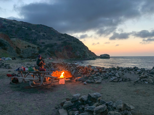
Santa Catalina is one of several islands located a relatively short distance off the coast of Southern California.


It's permanently inhabited by around 4,000 people most of whom are centered around the main settlement / tourist attraction known as Avalon.  Most of the rest of the island is controlled by the Catalina Island Conservancy and has a more rustic feel to it despite the existence of dirt roads and cell service almost everywhere.  They do control vehicle access but you can pay to get almost anything including yourself delivered to one of only 5 campgrounds.

The island is also famous for the buffalo herds that were originally transported to the island for a movie only to be abandoned and have lived there ever since.  And there's also a unique species of fox that is only found on the island.

There is a trail that runs from one side to the other called the Trans-Catalina Trail that's been on my radar for years.  Since I'd only ever been to Avalon it seemed like an ideal way to see more of the island.  I never got around to it before now mostly due to the cost and extra hassles involved vs my usual Sierra or desert based weekend adventures.  You have to reserve campsites, pay for a boat ride, and I'd heard from others that it was mostly a steep hike on fire roads.

Then this year I let Jen Blackie convince me to finally take a precious four day weekend in between WTC and AMP and head out there.  And it turned out to be one of my favorite trips of the past few years despite the odd mix of civilization (cellphone coverage, vehicle access to the entire island) intruding into the wilderness-y experience I'm generally looking for.

Kaweah WTC Snow Camp 2018 Goes Negative!

March 16th to 18th, 2018
[Pics] [Map]

Each year the 10 week Sierra Club Wilderness Travel Course builds up to a three day two night winter backpack outing into the Sierra Nevada.  And each year the staff nervously watch the snow forecast hoping we don't have a repeat of 2015 where we barely had enough snow to set up tents on.

This year it looked grim until right before the snow travel outing at which point a series of storms starting hitting both the local mountains and the Sierra.  By the week before snow camp we knew we were in for something memorable.


Even if the weather fizzled (which it didn't) this was looking to be the coldest snow camp in years!

Sheep and Martinez Backpack Santa Rosa Wilderness

February 23rd to 25th, 2018
Sheep Mountain (5,141')
Martinez Mountain (6,562')
Day 1: 2.4 miles, 300'
Day 2: 10.5 miles, 2,500'
Day 3: 9.7 miles, 2,500'
[Pics] [CalTopo] [Map]

Wilderness Travel Course season gets pretty busy with most weekends being tied up in class outings but we do have the occasional opportunity to get out.  This trip was snuck in between the Orange County Joshua Tree and Snow Travel weekends.  In addition to just being a good excuse to get out and backpack in the local mountains was as an I Provisional for Jen Jones and had the added benefit of being a variation of something I'd done before that I'd wanted to scout as a potential WTC Experience Trip.

Unlike most trips where we drive out the night before and hike in in the morning our plan was to do the initial 2.5 miles Friday night to a known water source and then fill up in the morning and do another 2.5 miles to a dry camp near Cactus Spring.  We'd then dayhike Martinez, return to camp, and then Sunday do Sheep before hiking out.

And as an added bonus we had a winter storm sweep in dropping the temperatures to a low of 27.  Fun!