Mount Starr King Yosemite WTC Experience Trip
- Updated: September 23, 2017
- Post By: Matthew Hengst

September 22nd to 24th, 2017
Mount Starr King (9,092')
Day 1: 10 miles, 1,800'
Day 2: 3.3 miles, 2,000'
Day 3: 8.2 miles, 1,700'
Mount Starr King is a granite dome located near Half Dome and is one of the 247-ish peaks on the Sierra Club Sierra Peak Section list. It's higher than Half Dome though it lacks the massive cliff overlooking Yosemite Valley which makes the other so iconic.
Also unlike Half Dome there are no cables or other mechanisms to get to the summit of Starr King except for doing a bit of 5th class climbing. This means it's visited a lot less often than it's neighbor.
This would be the 4th time on the summit for Jack Kieffer and I. We've been leading it biannually for a number of years now and have settled on a relaxed 3 day schedule camping well off the trail. The nature of the climbing lends itself to being able to safely bring along a decently large group of varying experience levels which makes it ideal for an exciting Wilderness Travel Course Experience Trip.
This time around we had along a group of 16 people with an additional 30+ more who had requested to join but we didn't have room for them on the permit. And this time it got interesting right off the bat when our trailhead ended up being closed due to to both being technically on fire while also covered in snow...
Our plan for Thursday night was use our usual trick of spending the night at the Mono Meadows Trailhead with a few of us waking up early and driving down to the valley to grab our permits.
Then the Empire Fire happened which came close enough to close Glacier Point Road intermittently. We called a few days out and were assured the road and trail would likely be open and that even if it wasn't they would honor our permits and let us enter at another trailhead.
Then a storm blew in dropping enough snow to close both Tioga and Sonora Passes in addition to causing them to once again close Glacier Point Road. Our first person up there was told road access would be reevaluated at 7 am the following morning.
First I figured we'd use Summerdale Campground right outside the park entrance which has had open spaces in the past. Turns out that is closed due to a different fire until the end of the season.
Looking online I found there was dispersed camping nearby at the Goat Meadow Snow Play area at the end of Raymond Rd. However when we got as vehicle over there we found the road closed due to the same fire operations.
Finally we drove south of Fish Camp and found the first dirt road that wasn't totally closed due to a fire and sacked out with great relief. And then woke up a few hours later for the drive into Yosemite Valley.
The rest of the group had ended up in a combination of parking lots, road side pullouts, and hotels and I sent word we'd meet for breakfast down in the valley.

It took us about an hour and fifteen minutes to drive into the valley and being early in the morning we found plenty of parking options.

I intended for everyone to meet at the Yosemite Valley Food Court but after looking online I mistakenly thought it was called the Half Dome Village Pavilion. This resulting in most of the group ending up at the latter while Kristen, Jack, Victor, and I slurped down some surprisingly good coffee at the former.

We eventually got that sorted out and everyone met outside the Visitor's Center while Kristen and I ducked inside to grab our permits.
Yosemite backcountry permits restrict groups to 8 people if you want to do cross country. As a result we had two permits with 8 slots each entering from two different trailheads. One planned to come in from Mono Meadows while the other would take a slightly longer route in from Glacier Point.
The good news was Glacier Point Road was now open to traffic. The bad was that Mono Meadows was apparently currently on fire.

Fortunately the rangers happy to swap our Mono permit for Glacier Point as long as we avoided the closed trails. That meant we'd have to go down to the footbridge crossing the Illilouette near Panorama Point adding a bit of additional distance and gain but on the plus side we didn't have to start from Happy Isles which was the next fallback.

Permits in hand and group rallied we all headed for Glacier Point stopping only briefly for Kristen to talk to some deer.

They weren't kidding when the said Mono wasn't usable. It was still actively smouldering when we went by...

...followed a short distance down the road by the remains of not an insignificant amount of snow. At this point I started to really regret not having declared a Game of Thrones fire and ice theme for the climb.

Our first view of Starr King was in the distance through the smoke which wasn't encouraging. Fortunately things looked a bit better once we reached Glacier Point.


We could see some snow on Starr King and the surrounding area but it didn't look like anything that would cause us too much trouble. The higher peaks in the distance like Mount Clark (immediately to the left of Starr King) seemed to have gotten a lot more.
I led the first group in with the second following some time later with the plan of camping near the same place and connecting that night.

Other than a slight haze and the snow covering all the higher peaks conditions were quite pleasant.

Using the footbridge this time of year was hardly necessary though at least we got to enjoy the interesting diagram and grammar choices of the sign.

We made a brief stop by the point where the old Panorama Trail looks down a two thousand foot drop to the valley. It's enough to mess with even those of us not normally bothered by heights.

The clouds were starting to look a little bit threatening and we could see the other group coming down the trail from Glacier Point so we kept moving.

We saw a steady stream of people coming up the Panorama Trail but once we turned off towards Starr King we didn't see anyone else.

Technically we could have stayed on the trail a bit longer and avoided some of the bushwhacking but I wanted to determine if we were going to have water near our intended camp so we cut across Starr King Creek.

At least down here there was plenty of water which Victor verified by almost falling in in a very dramatic fashion.
We continued up the drainage to Camp SK which is a location I've used several times now. It's relatively flat and has plenty of room for tents but you have to hike back down the hill for water as the creek runs dry at some point.

Finding enough water to filter again involved a bit of bushwhacking but we found some nice pools about 1/5 of a mile down. (I would recommend bringing filters here just because of the particulates in the water which can be unpleasant to drink. I'm not really concerned about giardia back here.)


Surprisingly campfires were still allowed in this area and we took advantage of the abundant fuel to warm up a bit.
It got down below freezing that night which made for a chilly pre dawn wakeup. We were hiking by 6:15 the next morning once again split into smaller groups.

Jack and I took the group that left first which meant we had to carry all four ropes plus the climbing rack. We aimed straight up the hillside aiming for the saddle between the two southern domes.

The climb up the middle dome from the saddle I've seen described as class 3 but it's an easy friction slope you can just walk up.
Which brought us to the main attraction the southeast face of Starr King:
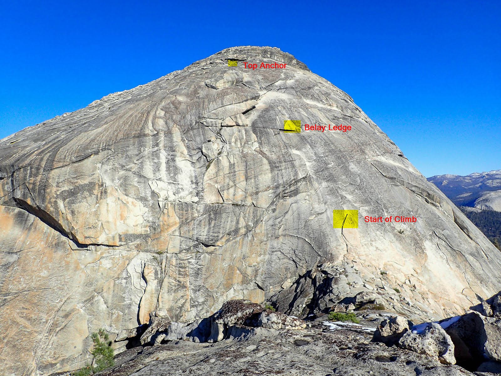

Jack led the first pitch setting up an anchor and then bringing me up behind him.


There was an anchor already set up at the belay ledge. Several pieces of webbing and cordelettes were wrapped around a rock stuck behind a fair sized boulder. However the rock it was wrapped around moved when I whacked it so we decided we liked slinging the big boulder in front a lot better. (It's trapped in place by some larger rocks behind it.)

I belayed Jack while he led the second pitch and set up the top anchor. Meanwhile I brought up Catalina with another rope and started setting up the telepherique.
Due to the slope throwing the rope down is a real pain especially with as many people as we had. I prefer to set up a telepherique but due to the length of the pitch you can't do the type where both ends of the rope are at the base.

We used two 60m ropes tied together with the bottom rope basically there as a pull cord on the way up. The climber clipped into the red rope just above the join knot which allowed the person at the bottom to pull the knot back down after they were done climbing.
We set up the top pitch in the same manner and by the time we were ready the second group had joined us at the saddle and we were ready to get climbing!

Last time I'd let people just use boots and we'd had some folks struggle on the friction heavy route. This time rock shoes or approach shoes were required for all participants which helped significantly. The only hitch was a short section about halfway up the first pitch where you really have to watch your footing a bit but since we were belaying from the top people really couldn't fall any distance.
I was stationed at the bottom checking harnesses and talking people through what they would be doing. At the belay ledge I had two people. One belayed the climbers up the first pitch while the second got them clipped into the second rope so Jack could belay them up the second pitch.
We had people climbing by 11 am and everyone was up top by 1:45 pm. We basically had people on the ropes at all times and used radios to communicate between the stations.


The register box is one of the old cast Sierra Club boxes this one dating back to 1937. The registers inside go back decades with the most entertaining entry being this one from 1985

"...forgot to say we hang glided from the top of Mt. Clark - Wasn't too bad except for the snow & ice that formed on the wings. Good thing I had my gortex shorts. See ya!"
More old entries can be seen online here.

We had two climbers come up behind us and let them rappel down our ropes first since they were dayhiking from Happy Isles. Then it was our turn.
Getting 16 people down and stripping all the gear took about 2 hours. We had fireman belays on both strands and again we had people at each station so we could double check everyone's riggings and talk them through any difficulties.


The clouds had swept in from the direction of Glacier Point and at one point I thought we might end up with some some fresh now. Fortunately the weather held but the temperature dropped significantly leaving those of us at the top stations very grateful we'd decided to wear long johns that morning.

I was the last person down. After some testing I decided the wiggling rock at the belay ledge was safe enough for one person and gently rappelled down before pulling the rope.


Fortunately the temperate went up once we were off the dome and camp was only a short distance away.

We could see smoke plumes off to the west near Mono Meadows backed by a rather nice sunset. From the top we'd been able to see a second smaller fire to the north near Starr King Lake.

The temperature dropped sharply when the sun went down and everyone was once again very grateful to have a fire. I normally try to be the last person up on nights like this but the days activities left me so exhausted I turned in early after making sure we had a plan for dousing the coals.


The next morning it took us about 4 hours to hike out though we had a wait for the second group to catch up to us at Glacier Point. We spent the time soaking up the sun and watching tourists excitedly photographing squirrels.


Interestingly enough if you ever wondered what happens if you're parked up on Glacier Point Road when it gets close down due due to snow the car parked next to us had be all appearances been there since before the storm and had the above card on it's window.

One vehicle had to be jumpstarted which briefly worried me considering there's been two stranded cars this season but soon we were all headed down the hill for our traditional post trip mexican food celebration.

Our destination was El Cid in Oakhurst home of good food and some really nice margaritas graciously donated by happy participants.

After a few of those previously mentioned margaritas and an epic battle with an errant birthday balloon (which had escaped from a different party only to be repeatedly brutalized by the cieling fans) we said our goodbyes and headed for home.
Our carpool made it back to Orange County around 1 am which is downright reasonable considering the length of the drive. Now I had 5 -ish days back in town until I planned to be back in Yosemite for a four day peakbagging loop out of Tuolumne. Assuming the weather cooperates that is...
0 comments