Muddy Peak In Clark County Nevada
- Updated: November 18, 2017
- Post By: Matthew Hengst

November 18th, 2017
Muddy Peak (5,387')
9.2 miles, 3,200'
9.2 miles, 3,200'
As much as I really enjoy the volunteer classes I teach through Sierra Club they do wear on me a bit since they keep me in town during periods I'd rather by running amok in the wilderness (otherwise known as each and every damn weekend) So it was with great relief I wrapped up my commitments last week and set about making some last minute desert plans.
Muddy and Moapa are two peaks on the Sierra Club Desert Peak Section list. They are located north of Vegas along the 15 in the general vicinity of Valley of Fire. They're both 3rd class (with Moapa in particular being known for an extended summit ridge with a bit of exposure) and are really quality examples of what the list has to offer.
We planned to drive out Friday night, climb Muddy Saturday and then camp along the road out, and then do Moapa Sunday before driving home.
We had a group of 8 joining us for Muddy with another two meeting us for Sundays climb of Moapa. As usual we intended to leave OC at 7 pm to miss the worst of the traffic along the 91 / 15. Unfortunately the last week had involved several thousands of work on Kristen and I's vehicles and the tail end of that resulted in her stranded without a car late enough on Friday. As a result we didn't end up leaving the park and ride until closer to 8.

Fortunately traffic cooperated and we made good time.
There's a gas station at the exit from the 15 (which is also the exit for Valley of Fire) suitable to gas up and get any last minute supplies. Then after about 3 miles of pavement the road turns and you continues southwest along what starts out as a very good dirt road.

We slept at a pullout along the first road before it got rough at Buffington Pockets. There are several of these and the biggest challenge is finding one not already occupied by campers running obnoxious generators all night. We found our spot and sacked out by a rather reasonable 1:15 am.
We stayed here instead of the trailhead because the road through Buffington Pockets was known to be rough and I'd heard through the grapevine it had gotten worse since I was there in 2011.

The road was rough but we made it through easily in a Jeep Wrangler and a 4 Runner without any need for four wheel drive. (I'm not exactly sure how I managed to get my Rav4 back here in 2011 other than I will say that's the closest I've ever come to flipping a vehicle)

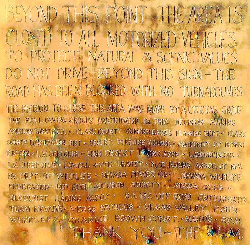
The road eventually ends at a trailhead with a rather heavy duty sign explaining what groups can be blamed for the fact you can't drive further. This apparently upset a few people as there are numerous bullet holes and it looks like someone made an attempted to pull the thing out of the ground.

We were hiking a little before 9 am. Past the barrier the road continues up and over into what's marked on some maps as Hidden Valley.

We left the remains of the road at this point and set off towards the peak to the south. You can follow traces of roads a bit further but it's not going to gain you much.

There are several outcroppings of impressively colored red and white rocks that would be perfect for a photoshoot assuming you didn't mind hoofing it back here. Particularly right before you enter the canyon to the peak there are some really red rocks. Here they are on the way out when unfortunately the light didn't do them justice.


The canyon at the south end of the valley leads up to a saddle where we swung to the east and gained the northwestern ridge to Muddy.


The terrain is typical desert roughness with some fun 3rd class scrambling starting along the ridge.


The rock here is amazing because of how grippy it is. You barely need to pay attention to footholds since you can smear on any surface. Just don't bring trailrunners unless you want them shredded.

The last 300 ft or so is a fun scramble straight up the northwest ridge.


We did the lower section in stages since there's a lot of loose rock that is easy to kick down on fellow climbers.

We saw three of these rap stations set up with slightly questionable anchors. We had a small rope along as a precaution but the scrambling is pretty straightforward and we never came close to using it.


I was a little bummed we didn't get a better view of Valley of Fire considering how close it was but that place is so low we could barely make out red rocks peaking over a ridgeline in the distance.
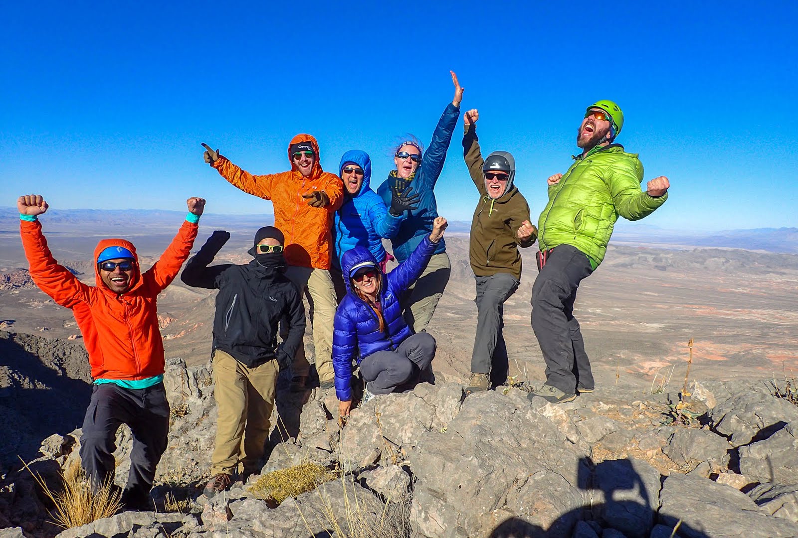
We made the summit around 1:15 pm.

We another group had been up there on the 12th and the register was filled with signins from friends including my own trip from 2011.

The sun goes down early this time of year so we didn't spend too much time dawdling up top. We started down at 2:10 pm.


The sun goes down before 5 pm this time of year so we didn't expect to get out in the daylight.


We left the trailhead at 8:50 am and made it back at 5:35 pm with the last hour or so being in the dark.

We found a suitable campsite with a suitably XL sized pre existing fire ring just north of the old CONC. DAM marked on the topo map.

We had a pleasant night with a warm fire and an international cuisine including two different curries, lentils, pizza, cheese and bread, pastries, pumpkin pies, and some very well appreciated libations.
0 comments