Picacho Peak Near Yuma
- Updated: January 20, 2018
- Post By: Matthew Hengst

January 20th, 2018
Picacho Peak (1,920')
3.8 miles, 1,300'
Picacho Peak (sometimes referred to as Little Picacho on the Sierra Club Desert Peaks Section list) is a spectacular volcanic plug located north of Yuma.
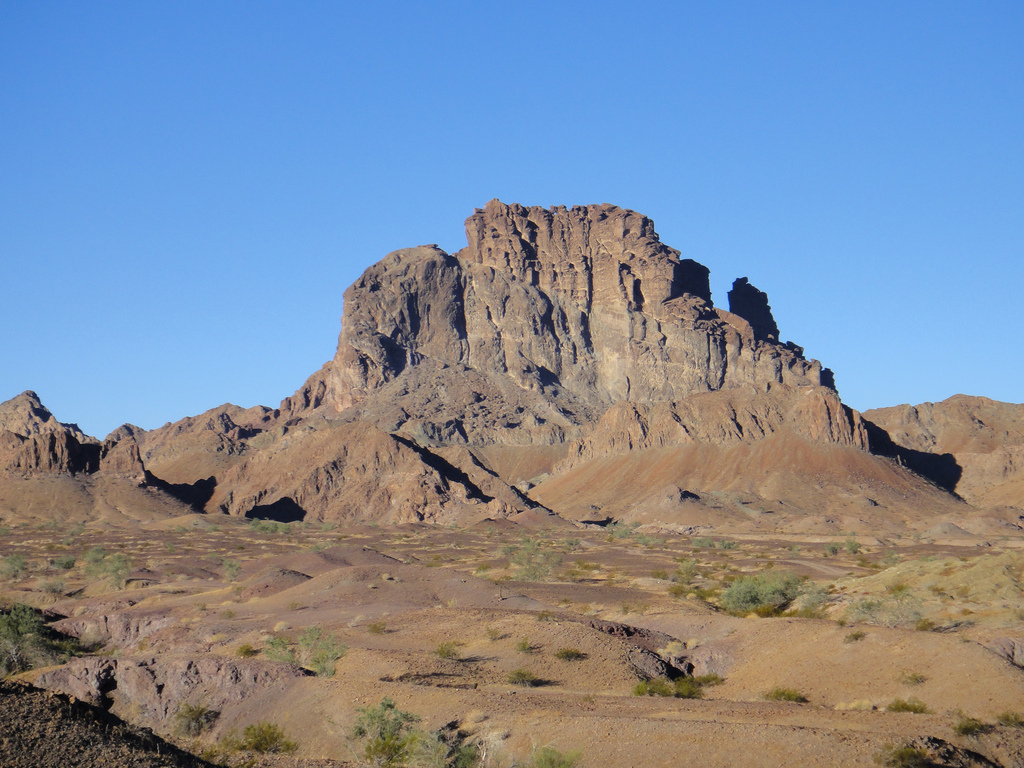
From a distance it looks impossible but approached from the west there's a notch leading to a series of ledges which involve 3rd class scrambling, an awkward stepacross, two slightly sketchy ladders, and a summit ridge that requires a 4th class bit, 2 rappels, and finally a slightly challenging ascent if the rope. (The last part is why the peak is listed as the hardest technical peak on the DPS list)
It's always struck me as a perfect fit for people who have completed the Sierra Club Advanced Mountaineering Program and are looking for a way to practice the skills they learned. I'd been toying with leading it officially as an AMP Experience Trip of sorts for a while now and this was the result.
This was my 3rd time up Picacho. I initially did it back in 2011 from the east with just two people and then again in 2012 from the north as a part of my Sierra Club E provisional in a slightly hectic day where we also summited the mighty Stud Mountain.

This time we had 15 folks counting my co leader Jack Kieffer and myself. That number also included several AMP staffers to help move everyone through the choke points more quickly.
Despite the fact it was pouring rain when we left Orange County Friday night the forecast called for wind but 0% chance of rain. Yet somehow my personal luck seems to *occasionally* override forecasts like that...
Kristen and I picked up our carpool around 7:40 pm reached our trailhead a little before 1 am.

We spent the night along one of the canyon turn offs you can find along Picacho Road. It was a bit on the windy side so I don't think anyone got a great night's sleep but hey, sleep is optional when you're running around the wilderness!

Jack and I had figured we'd probably end up doing the peak via the longer route from the east since it requires less rough road driving. However looking at the vehicles we had we decided to at least try and make the northern trailhead.
We had a few Jeeps, a Crosstrek, and a Ford Explorer. I'd remembered the road as being rough but as it turned out I could have made it back there easily enough in Kristen's Forester if we'd had it. The Ford Explorer was a little on the low side and had a few scraps here and there but we ended up getting all 8 vehicles to the end of the road.
Camping options are much improved near the northern trailhead. We ended up staying at the end of the road but there were a number of others before that most of which had firepits.

We carried more gear then usual on this one since we had to move a large group
- 2 30m climbing ropes (enough to set up both sides of the summit ridge block at the same time)
- Climbing rack with BD .5 to 3s and a few mixed smaller Metolius cams for the step across anchor (we ended up using the BD #.75, BD #1, and a Metolius TCU #3)
- Three cordelettes (step across anchor, summit ridge left and right)
- 4 small utility locking carabiners (for the summit ridge bolts left and right)
- 3 larger belay carabiners (for the step across, summit left and right)
- 2 petzl ascenders plus blocker carabiners
- A double length and single length sling for use with the ascenders
In addition all participants were responsible for the following
- Climbing helmet
- Climbing harness
- Personal tether or a double length sling + locking carabiner
- Belay carabiner + ATC device
We started hiking at 7:45 am and followed a wash south from the parking area. The nice thing about this route is you only have about a half mile before you start climbing the peak vs the 2+ miles if you approach from the east.


We climbed up to the saddle that both routes aim for and then traversed towards the canyon that marks the start of the fun stuff. One minute we were following a use trail and the next we were doing some light 3rd class downclimbing on slightly rotten rock which did provide a nice warm up before we got to the main event. (We took a more direct route skipping the saddle on the way back and that was rough too. Maybe staying higher from the saddle would work better)

This is the notch where the route begins in earnest.


Once to the notch you find your first route indicator. While you might expect the usual pile of rocks, piece of webbing, or maybe even a subtle paint dot someone went whole hog and painted big green arrows to make the route abundantly clear. And they'd even been repainted since I did this years ago.

Following the arrow up we could see the crack of the stepacross above. That's the first major obstacle.

Well, unless you count the slightly cracked wooden ladder. Just make damned sure you don't pull out near the top.


None of the pictures really convey the stepacross well. It's narrow enough you can step across it on the outside but you're landing on rock which slants out over a fair drop. The easier route is to climb down into the crack higher up using the ample foot and handholds to get across the top.
For what it looks like jumping across (with bonus broken ankle action) see here.
On past trips most people had done it without a belay and when it was needed I used a hip belay on boulder you can see at the bottom of the picture below. It was decent enough but the angles are all kinds of awkward and I just never felt good about it.
The crack right above the stepacross might have taken #4 or larger cams but any placements for smaller sizes seemed to be too far back to be accessible. I thought we were going to have to use the boulder when we found a crack on the far side of the stepacross where we could get some good placements.


We ended up using a Camalot #2, .75, and a Metolius TCU #3 but the crack had a few other options around that size. Just be aware not all the placements in there are solid so we had to be a little choosy. We then threw a cordelette, tied a masterpoint, and we were ready to go.

I had Tohru doing a munter belay around the corner while I stayed at the far side of the stepacross and directed people while managing the rope to prevent an overtight belay from pulling someone off the rock.


 |
| Oops, looks like we lost one... |
This worked well and by 10:30 am we had everyone across.

We left the anchor setup but pulled the rope since we'd need it up top and then followed the arrow up to the next ramp. And then another arrow up another ramp until we came to the second ladder and the sketchiest part of the whole endeavor.

Why do I call this the sketchiest part you ask? Don't I see the webbing connecting it to the rock? I mean yea, it's a big ladder but it's quasi connected the rock and the drop off the side of the peak is several feet away...

The webbing

One of the "bolts"

Notice how much the ladder flexes.
We stabilized it as best we could from the top and the bottom and identified at least one person with a hitherto unidentified fear of ladders. So at least there was that!
Past the ladder was the summit ridge itself.

Picacho is interesting because the summit is behind the rock you see me sitting on. You have to climb the rock, rappel down the far side, then ascend the rope and rappel back down the near side. (I've heard of people bypassing the summit block around the right with exposed 3rd class but I've never done that since you miss the funnest part!)

The climb isn't hard but it's a 1,200' -ish drop right behind you. There's no protecting it other than a catastrophic belay off to the side it but it's relatively short and straightforward. Once you get up top there's a few bolts that none of us were the biggest fans of but were solid enough for a belay and rappel.

We set up a telepherique and started belaying people up one after another. This started around 11 am.

On the far side of the rock we set up another anchor using the existing bolts and started people rappelling down as they were ready.

The last person was down the far side by 12:10 pm.

Once past that the summit is an easy stroll and we had everyone on the summit by 12:15 pm.

The summit register is an interesting case where someone actually glued the tube into the rock.

There's also a boy scout book placed by Troop #4097 which claims responsibility for pulling the old registers and putting them in the Yuma County Library. We ignored that and signed into the climber register which still had Jack and I's original sign in from 2011 and the return in 2012.

And there's various other objects of interest scattered around...

After enjoying the impressive view up top we started back at 1:15 pm.

The hardest part of the return is just getting back up the summit block. I've heard the climb being called an overhung 5.9 but it looked fairly doable. The only downside is you have to go off to the right of where I'm hanging in the picture above so you're literally dangling off the side of the peak.

We had two ascenders on the rope. The top one had a single length sling people clipped to their harness while the lower one was used as a foot loop.

Per Sierra Club rules we did an additional belay from the top with the other end of the rope. Just to be safe.


It took a fair amount of effort particularly wearing packs. (The smart folks dropped their packs and clipped it to the rope below so they could pull it up after they made the top)

As soon as people were up top we started them rappelling down the far side. We wanted to keep everyone moving but the ascent took significantly longer than the rappel.
Also we couldn't help but notice the clouds in the distance appeared to be dropping a bit of rain. And that they seemed to be getting closer.

That made us hustle just a bit faster and I sent Jack ahead with part of the group to start belaying back across the stepacross. And then just about as I was coming to terms with how awesome the trip report was going to be featuring the stepacross as a flowing waterfall the storm changed direction and blew past to the north. At least it left behind some rather spectacular rainbows.


The picture above is showing the rainbow terminating at USGS Little Picacho which we climbed the following day.
The last of us were finally off the summit block and heading down at 3:30 pm.

The group we'd sent ahead had crossed quickly by 4 pm Jack broke down the anchor and was the last person back across.

It's significantly easier to cross coming back but you do have to commit.

After that it was down the ladder (which did flexed alarmingly a few times due to the crack near the top) and we were down with daylight to spare.


Instead of going back to the saddle we shortcutted directly down the slope to our return canyon. This was also rough going with lots of boulder hopping and some loose ground here and there.

There are a number of other interesting looking bumps in the area. Sometime I really intend to come back out and spend a few days scouting out anything that looks halfway fun like point 1,474' here.

We made the cars just a bit before dark and went about establishing camp.

We made use of the nice firepit in the middle of the loop and people set tents on the ample flat ground to the east and west. We did have one moment of alarm when Alex showed up at the fire requesting to use a headlamp because his tent had gone missing. After some time wandering around in the dark Victor managed to locate where the wind had blown it which was a good stroke of luck. And we all learned a lesson on why you leave water jugs or something similarly heavy in your tent while desert camping.
The next morning we woke up early and planned to do USGS Little Picacho a short distance to the north.
0 comments