River Coordinates, GPX Tracks, & Distances | Mississippi River Source to Sea
- Updated: August 27, 2023
- Post By: Matthew Hengst
Someone who wasn't familiar with the Mississippi River might assume that there would be a map somewhere with a set of river miles starting at the headwaters and counting down to zero where it reaches the Gulf of Mexico. Sadly the reality is a little more complicated.
This is part of a series of write ups about our 2023 paddle of the entire Mississippi River from the headwaters at Lake Itasca down to the gulf of Mexico. For more click [Mississippi Source to Sea] or see our YouTube channel.
There are actually two major river mile coordinate systems for the Mississippi River.
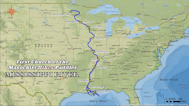
Upper River Miles (URM) go from URM 1,342 at the Lake Itasca headwaters to URM 0 at the confluence with the Ohio River at Cairo.
At that point the river switches over to Lower River Miles (LRM) starting with LRM 954 and count down to LRM 0 at Head of Passes down past Venice.
If you take the New Orleans route the actual point where you reach salt water at the end of south pass is 13 miles past Head of Passes or LRM -13.
If you take the popular alternative down the Atchafalaya then we couldn’t find an official set of coordinates but mapping the route we found to be most commonly used by paddlers exiting via Hog Bayou is 141 miles from Old River Lock. So a person grasping for order might say Old River Lock is ARM141 and Burns Point is ARM0.
Having the actual river miles was useful for tracking our daily progress and also for getting a handle on where certain river angels were located when they reached out on the Facebook group.
So now that you know the river miles exist how would you figure out what you are at while your actually on the river?

Initially you have it easy as the start of the river is covered by 10 Minnesota DNR maps you can find here or download using the Avenza phone app which will show you your location on the PDF. River miles are listed for all major points of interest making it really easy to keep track of everything.
Unfortunately these only cover as far as Hastings and we never found an ideal replacement.
Lower down the river there are physical nav beacons on the shore which sometimes have the mile on them. But be aware that the Mississippi River has a tendency to change over time and at least one Army Corp of Engineers document I found only guarantees the nav buoy numbers were accurate to 15 miles. They had a note that they generally do their best but don’t treat anything like gospel.

There are additional Army Corp of Engineers charts for the river but these were so zoomed it as to be less than ideal for our uses.
At times we saw houses or other locations on the river labeled with the river mile but this was inconsistent.
I wanted to keep it simple and have mile markers on my phone GPS app so with a huge amount of help from our friend Dennis (aka the awesome guy who makes those lovely maps at the start of each of our videos) we came up with the following. Take it, use it, hell get the army corp of engineers to republish it for all we care. The universe could use the extra bit of sanity.
So in summary
Upper River Miles (URM): Headwaters URM 1,342 to Cairo URM 0
Lower River Miles (LRM): Cairo LRM 954 to Head of Passes LRM 0
Actual end of the New Orleans route LRM -13
Atchafalaya Route: Old River Lock A 141 to Burns Point A 0
For a more logical way to divide up the river see my writeup on the river by sections.
Note that this means your total distance paddled from the headwaters to the gulf is somewhere in the vicinity of 2,309 miles if exiting past NOLA or 2,133 exiting via Atchafalaya. Also anyone actually doing the river has probably done a fair chunk extra along the way.
3 comments
Can I get a list of names and addresses of River Angels in the upper Mississippi River?
ReplyDeleteUnfortunately they don‘t choose to publish that information. You have to make a post in the Mississippi paddlers group and let anyone interested reach out to you. That is a big part of the reason we interacted with so few River angels on our trip
DeleteJust imported the lower Mississippi line nd mile markers from your public caltopo files. You sir, saved me 87242038 hours of pain and suffering. I’m headed down the river starting next week to stop in New Orleans where you and I have a mutual friend who likes to keep his name out of things. Thank you again for sharing your map data.
ReplyDelete