Why the Mississippi River Might Be the Best Long-Distance Trip in the U.S.


If you've been following our adventures you know we are primarily thru hikers though we do enjoy a good long distance paddling trip when the opportunity arises.
 
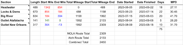
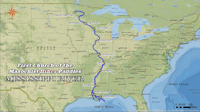
Right in the middle of working my way through the Triple Crown of Hiking I found out about something I never knew was an option in the modern day: paddling the 2,300+ mile Mississippi River from the headwaters in Minnesota down to the gulf aka the Mississippi Source to Sea or MS2S.

Similar to a lot of folks I primarily associated the Mississippi with having read Huck Fin in school. Meanwhile I had the impression that in the modern day that traveling down it in any sort of a paddle craft wasn't really possible as it had become more of an industrial / shipping river.
 
Then I came across a random website while hiking the CDT that not only explained it was a thing but mad it sound amazing. 
 
Considering I'm someone who stays relatively well informed about all the various long distance outdoor activities I was surprised something like this existed and that I hadn't come across it. And now having done it myself in 2023 I'm really blown away that it isn't more popular. Because it's a really amazing trip. 

Two Ways to Finish the Mississippi River: The Atchafalaya vs Main Channel


Unlike a long distance trail there isn't a lot of navigation involved in paddling the Mississippi Source to Sea. From the moment you leave the headwaters you literally just go with the flow with the occasional option of which side of a given island to go around.

That all changes after 1,992 miles when the Atchafalaya splits off the now massive main channel and heads down to the gulf via a quiet series of gator infested swamps. Meanwhile the main river gets even bigger and busier passing by Baton Rouge and New Orleans before it's own quiet finish out past Head of Passes. Both are considered by the community to be valid finishes to the Mississippi Source to Sea.

One might be excused for wondering why the Atchafalaya is considered a valid finish to something called the Mississippi Source to Sea.

As near as I can tell this is mostly due to concerns of the heavy barge and oil tanker traffic in the main channel past Baton Rouge. When we did our initial research we found most people seemed to take the Atch. Possibly influenced by occasionally over the top fear mongering about the main river just not being safe.

There is also the justification that the Atchafalaya is where the main flow of the river would be going if it wasn't for the Army Corp of Engineers waging their ongoing battle to keep the ports of New Orleans and Baton Rouge operational.

In actuality I'd argue it comes down to it's shorter, it's quieter, and it's an easier finish logistically.  

So which did we take? We went overboard and did both. Back to back. We had just enough spare time left to manage to get down to Burn Point on August 4th and then catch a river angel ride back to Old River Lock and pick back up on the main channel for a second finish August 18th. Hence our paddle being 2,450+ miles instead of the usual 2,300 / 2,130 miles.

As far as I'm aware we're the only ones to do both routes back to back though plenty of folks have gone back to do the one they missed another year. So for what it's worth here's my best attempt at an apples to apples comparison of the main channel vs Atchafalaya finishes of the Mississippi River Source to Sea in the same weather / water level / mindset.

Canoe vs Kayak for the Mississippi Source to Sea: What We Used and Why


In the summer of 2023 we paddled 2,450 unforgettable miles down the Mississippi River from the headwaters in Minnesota all the way to the gulf.

Since then one of my passions has been spreading word about just how accessible, and seriously underrated, this trip is. For anyone interested in long-distance adventure in the U.S. the Mississippi River is truly a top tier experience.

After completing the trip ourselves and comparing it to several years of posts from others attempting it one thing stands out: a lot of people make it harder than it needs to be. And a good part of that comes down to gear particularly boat choice.

I’ve seen countless posts about brutal portages usually paired with photos of overloaded heavy plastic or metal boats stacked high with too much gear. 

Short version: get a used Souris Quetico '17 or similar type canoe and enjoy.

How We Got to and From The River | Mississippi River Source to Sea 2023


Unlike a trip of a few hundred miles where you can generally rent a boat and get shuttled back at the end our epic paddle down the Mississippi saw us covering 2,300+ miles and crossing nearly the entire country. And so the process of getting to and from the river was a little bit more involved.

Powering Our Paddle With a $250 Voltaic Solar Box | Mississippi Source to Sea 2023


The piece of gear which provoked the most comments during our extended journey down the Mississippi was our solar box. I assembled it from pieces sold by a company called Voltaic with the goal of having something we could just set out on the boat and have it generate power without us having to micromanage it when the weather got bad.

I have always loved the idea of solar but at least so far I've found that the state of technology doesn't really lend itself to being usable on long distance hikes. When you're getting started early and hiking until evening you can't really set a panel out for any length of time during the effective hours of sunlight and putting it on the pack while hiking usually doesn't work real well due to the fact you invariably end up partially shading the panel. And then there's the fact that lighter panels tend to be fragile and even the few folks that I've met who have made it work seem to have had to replace them multiple times. And I'm harder on my gear in general than all those fine folks.


But when we started planning for our Mississippi Source to Sea paddle one of our goals was to avoid the constant need to go into town to charge our hiking batteries. Because it's one thing getting a ride into a hotel when all you have is a backpack and quite another when you have to deal with a 17 ft canoe loaded down with gear. And in fact we only slept in town 6 times over 75 days and when we did indulge it was never driven by the fact we were lower on power.

Since after the headwaters the river is quite wide we didn't have to worry about overhead trees shading the box. And I worked around the fragility issues by using a hard panel vs anything bendable or foldable.


And this was the end result which successfully saw us through 10 weeks and 2,460 miles despite all the rain, wind, boat wake, and heat waves. 

Our Mississippi River Thru Paddle By The Numbers | Mississippi River Source to Sea 2023


Matt & Jen's Daily Mileage Stat Sheet
Daily Videos

It took us 60 days to reach Old River Lock where the route diverges with two outlet options
It took us an additional 5 days to reach the gulf via the Atchafalaya ending at Burns Point
It took an additional 10 days to travel from the junction to the end of South Pass going by New Orleans


We were on the river for a total of 75 days
We took 0 zero days
We came off the river to spend the night 6 times

We resupplied 15 times
It cost us roughly $187 per person per week to be on the river excluding equipment costs

2,133 miles paddled from the headwaters to the gulf via the Atchafalaya
2,309 miles paddled not counting the Atchafalaya just headwaters to end of South Pass
2,450 miles paddled total in 75 days


Our longest day was 58 miles which was in the Big River section where we had some current and no obstructions.
The fastest current we measured was 3 mph which was after the Missouri came in.
Out fastest recorded speed was 6 mph but we weren't able to measure the wind sail day on Lake Pepin.

River Coordinates, GPX Tracks, & Distances | Mississippi River Source to Sea


Someone who wasn't familiar with the Mississippi River might assume that there would be a map somewhere with a set of river miles starting at the headwaters and counting down to zero where it reaches the Gulf of Mexico. Sadly the reality is a little more complicated.