Picacho Peak Near Yuma

January 20th, 2018
Picacho Peak (1,920')
3.8 miles, 1,300'
[Pics] [CalTopo] [Map]

Picacho Peak (sometimes referred to as Little Picacho on the Sierra Club Desert Peaks Section list) is a spectacular volcanic plug located north of Yuma.


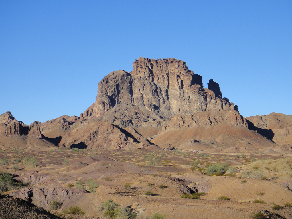
From a distance it looks impossible but approached from the west there's a notch leading to a series of ledges which involve 3rd class scrambling, an awkward stepacross, two slightly sketchy ladders, and a summit ridge that requires a 4th class bit, 2 rappels, and finally a slightly challenging ascent if the rope.  (The last part is why the peak is listed as the hardest technical peak on the DPS list)

It's always struck me as a perfect fit for people who have completed the Sierra Club Advanced Mountaineering Program and are looking for a way to practice the skills they learned.  I'd been toying with leading it officially as an AMP Experience Trip of sorts for a while now and this was the result.

This was my 3rd time up Picacho.  I initially did it back in 2011 from the east with just two people and then again in 2012 from the north as a part of my Sierra Club E provisional in a slightly hectic day where we also summited the mighty Stud Mountain.


This time we had 15 folks counting my co leader Jack Kieffer and myself.  That number also included several AMP staffers to help move everyone through the choke points more quickly.

Despite the fact it was pouring rain when we left Orange County Friday night the forecast called for wind but 0% chance of rain.  Yet somehow my personal luck seems to *occasionally* override forecasts like that...

Cerro Pinacate Mexico Margarita Bash Featuring Lava Caves And A Hellish Slog Up Carnegie

January 6th & 7th, 2018
Cerro del Pinacate (3,937’)
Carnegie Peak (3,707’)
9 miles, 3,300'
[Pics] [CalTopo] [Map]
[Garmin Mexico Maps By Harlan Stockman]

Cerro Pinacate is one of only 4 peaks on the Desert Peak Section list which are located in Mexico.


I've gone to climb this peak twice before.  In 2012 we were turned back at the gate due to"security concerns" and then in November of 2016 we made a special trip a month before I finished the DPS list.

It's a rather long drive from Orange County and despite really enjoying the area and the camp I normally wouldn't have made it a priority to do it again.  But last time I had a very limited window of weekends to do the trip and when Gracia was unable to join us I told her I'd go again.  So here we were again!

Moapa Peak In The Nevada Mormon Mountains

November 19th, 2017
Moapa Peak (6,471')
7.1 miles, 3,500'
[Pics] [CalTopo] [Map]

Yesterday we climbed nearby Muddy Peak and camped along the road out through Buffington Pockets.  Today our goal was another nearby desert classic Moapa Peak.

Moapa is also on the Sierra Club Desert Peaks Section list and is notorious for its knife edge summit ridge.  It's also one of the best on the list in my experience and makes for a great combo with Muddy for a weekend of scramble peaks.

Muddy Peak In Clark County Nevada

November 18th, 2017
Muddy Peak (5,387')
9.2 miles, 3,200'
[Pics] [CalTopo] [Map]

As much as I really enjoy the volunteer classes I teach through Sierra Club they do wear on me a bit since they keep me in town during periods I'd rather by running amok in the wilderness (otherwise known as each and every damn weekend)  So it was with great relief I wrapped up my commitments last week and set about making some last minute desert plans.

Muddy and Moapa are two peaks on the Sierra Club Desert Peak Section list.  They are located north of Vegas along the 15 in the general vicinity of Valley of Fire.  They're both 3rd class (with Moapa in particular being known for an extended summit ridge with a bit of exposure) and are really quality examples of what the list has to offer.

We planned to drive out Friday night, climb Muddy Saturday and then camp along the road out, and then do Moapa Sunday before driving home.

Glow In The Dark Desert Peak Section List Finish #1 On Nelson Range HP (Try #2)

December 3rd, 2016
Nelson Range High Point (7,696')
[Pics] [MapwDrive] [MapCloseup]

This was the final peak I needed of the 99 that make up the Sierra Club Desert Peak Section List.  (Actually there's 96 now since 3 have been delisted since I started)

I hiked my first DPS peak in 2010 and as I got near the end everything I had left was either far away or trivial.  I settled on Nelson Range HP which is an easy peak near Saline Valley which is relatively close as desert peaks go.  And since *one or two* of my adventures have been known to involve headlamps what better way to make it interesting but to do it in the dark!  And why limit it to headlamps?  And thus was born Nelson Range HP (7,696') In The Dark / Matthew Hengst Glow In The Dark DPS List Finish #1 of 2015.  People signed up and it looked to be a huge gathering of friends and a fun weekend.

Which I promptly had to cancel on account of my unanticipated knee surgery.  One year of slow recovery later and it was *finally* time for the Nelson Range HP (7,696') In The Dark / Matthew Hengst Glow In The Dark DPS List Finish #1 (Try #2).

Mount Stirling In The Las Vegas Spring Mountains DPS - Turktacular 2016

November 23rd, 2016
Mount Stirling (8,219')
[Pics] [Map]
3.4 miles, 1850 ft gain

Thanksgiving time and once again the plan was to escape civilization and go someplace awesome for the annual Turktacular trip.

Last year at this time I wasn't able to hike at all due to having knee surgery and settled for an overnight at a the always awesome El Dorado Hot Spring near Phoenix.

This year I was doing quite a bit better.  I was back to hiking and climbing and after a busy summer and after a few weekends of quick two day desert trips I was ready to get out for something longer and had a hankering to get back out to Utah.

I was also closing on finishing the Desert Peak Section List.  Of the 99 peaks on the list I'd just finished #97.  #99 would be Nelson Range High Point December 3rd & 4th but first I had one last orphan.  Mount Stirling out near Las Vegas.

I'd been out that way earlier this summer when I did Charleston & Mummy and decided against trying the peak due to the high temperature and low altitude though in hindsight I think I could have managed it as the peak is really short and easy.

Cerro Pinacate Mexican DPS Peak, Campout, and Lava Caves


November 12th & 13th, 2016
Cerro del Pinacate (3,937')
Carnegie Peak (3,707')
4.09 miles 1,900' in via the DPS route + Carnegie 
6.74 miles, 1,289' up and 3865' down out via the road
[Pics] [Map]
[Garmin Mexico Maps By Harlan Stockman]

Cerro Pinacate is one of the 4 Sierra Club Desert Peak Section peaks down in Mexico and one of the final three I needed to complete the list.

Normally it makes sense to combine this peak with a few in southern Arizona.  Ajo, Kino, and Baboquivari kind of naturally combine since they're roughly in the same area.  Except as this point I've done all of those twice (minus Kino which I've only done once) leaving Pinacate a very long distance orphan.

Red arrow points to Pincate

I'd actually attempted this peak before only to be turned back at the park gate for a very vaguely worded "security concern"  Having seen friends be let it before and after that I always wondered what was going on and this time when Jen called to verify we could get in she mentioned we'd been turned back.  Apparently that was the only time they'd ever shut it down and that was because they found some illegal radio towers and had kept out everyone for a season until it was resolved.

So here I was several years later still needing the peak and under the gun to get it before my December list finish.  With Jack Kieffer completely out of vacation days that limited our options for trying to do more than one peak so we settled on making it a party.  Come join us for a 400 mile drive, a campfire and overnight in Mexico, and a 6 mile hike (according to the DPS guide) followed by another 400 -ish mile drive.  We made plans for a festive happy hour and soon had 7 us signed up.

Canyon Point DPS From Cottonwood Canyon

October 6th, 2016
Canyon Point (5,890')
[Pics] [Map] [MapWPanamint]
5 miles, 3100', 3-4 hours (according to the DPS guide)

After climbing Panamint Butte from the west the day before our expectations had been lowered a bit.  Canyon Point seemed a little more promising due to the fact we'd be approaching via a canyon instead of just going up a ridge.

Panamint Butte DPS From Panamint Valley Big Four Mine

November 5th, 2016
Panamint Butte (6,584')
[Pics] [Map] [MapWCanyon]
7.1 miles, 4300', 11 hours

AKA a desert crap heap that really shouldn't be on the list when there's so much better stuff out there.

This and Canyon Point are some of the last few peaks I need to finish the Sierra Club Desert Peak Section List.  I've toyed with doing them a few different ways (there's a 4wd car shuttle loop option is apparently spectacular) but it was finally time to just get them done.  And with AMP just finishing I was ready for a good old fashioned desert car camp.

We decided to do Panamint Butte from the west climbing up from Panamint Valley at the Big Four Mine since the route up from Towne Pass was almost twice the distance and likely a bit much to be biting off at this point in my recovery.

Humphreys Peak (DPS) Arizona State Highpoint

August 7th, 2016
Humphreys Peak (12,633')
[Pics] [Map]

This was the second peak on a long haul DPS road trip to eastern Nevada and northern Arizona to pick up Wheeler and Humphreys.  See the writeup for Wheeler the previous day for how we got here.

I'd been by Humphreys before during a Turktacular but weather prevented us from attempting the summit.  Now that is was summer time it looked to be a pleasant half day hike before we had to haul back home to Orange County.

Wheeler Peak Nevada In Great Basin National Park

August 6th, 2016
Wheeler Peak (13,063')
[Pics] [Map]

I've been close to finishing the Sierra Club Desert Peak Section list for the last few years but only recently got serious about finishing it off.

I have all the hard ones (most done twice over) and most of the ones that require a really long drive.  However there were two that I've been staring at on Peakbagger for a while now due to the distances involved.


One is Wheeler Peak In Nevada.  It's the second highest peak in the state and really should be the state highpoint considering that Boundary (the actual highpoint) puts you just down a ridge from a higher peak right over the border in CA.

The other is the Arizona state highpoint Humphreys Peak just north of Flagstaff.  Easy hike, long drive.

Since the peaks are in the 12,500-13,000 ft range they are a bit easier to do in the summer.  They are also a long haul from Orange County but it seemed logical to try and knock them off together.


It was going to be a long weekend...

Charleston Peak & Mummy Mountain DPS Peaks Above Las Vegas

July 16th, 2016
Charleston Peak (11,916')
Mummy Mountain (11,529')
[Pics] [Map]

This was going to be a weekend spent at home catching up after spending the last few running around in the mountains but I couldn't take it.  Two days after getting home from Mineral King and managing some semblance of catching up on sleep I was ready to get out again.

Charleston Peak and Mummy Mountain are two peaks on the Sierra Club Desert Peaks Section list located just north of Vegas.  I've eyed them for years and even attempted them once (on New Years 2012 which turned that into just Griffith Peak) but either conditions were not promising or I ended up making other plans.

But now with less than 10 DPS peaks left before Decembers planned Glow In The Dark DPS List Finish #1 they suddenly seemed a lot more appealing.